)
Projects
The NSF GAGE Facility (hereafter GAGE) provides project support to principal investigators (PIs) engaged in research funded by our core sponsors including the National Science Foundation Earth Sciences (NSF-EAR), NSF Office of Polar Programs (NSF-OPP), and the National Aeronautics and Space Administration's Solid Earth and Natural Hazards (NASA-SENH) Program. Other non-core sponsors and agencies are supported on a full cost recovery basis. Some major projects in which GAGE is involved currently include the Network of the Americas (NOTA), NASA Geosciences and POLENET. See our projects help page to request support.
GAGE provides comprehensive project technical support services to investigators using GPS/GNSS, TLS, UAS, and SAR data. These services range from loaned equipment, testing, configuration, integration, and new equipment designs for field deployments to technical training for campaign field deployments and permanent station installations.
- Geophysical Event Response helps coordinate community field activities, hardware, and data requests following an earthquake, volcanic eruptions, or other notable geophysical events.
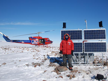
- Polar Services provides support to NSF-OPP funded scientific investigators working in the Arctic and Antarctic: survey-grade GPS receivers, terrestrial laser scanners, and supporting power and communications systems for continuous data collection and campaign surveying tested for polar conditions are available.
- Development & Testing for ongoing instrument & equipment testing of GNSS receivers & antennae, communications systems, and power systems for various GAGE projects.
- Data Management & Archiving is responsible for GPS/GNSS data delivery or pickup & conversion RINEX, long-term archive storage & FTP access of GPS/GNSS and SAR data.
- Education & Outreach Services provides support for Broader Impacts planning and execution of PI projects.
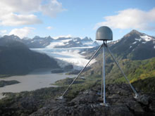
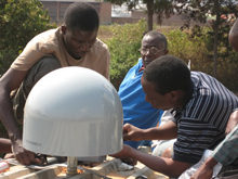
- GPS/GNSS Support provides PI support for projects using GPS or full GNSS:
- Terrestrial Laser Scanning (TLS) Support with instruments, associated digital photography GNSS and ancillary equipment, as well as trained field engineering staff, software licenses, and TLS data archive.
- Uncrewed Aerial Systems (UAS) Support with pool of small uncrewed aerial vehicles (sUAV's), and associated GNSS and ancillary equipment, as well as FAA certified field engineering staff, software licenses, and UAS data archive allows GAGE to support a wide range of geodetic imaging applications in Earth science research.
- Borehole Services provides expertise for borehole drilling and instrumentation for 3-axis seismic, horizonal strain, tilt, and borehole pressure.
- Note: Currently GAGE only supports laser strainmeters (LSM) through sub-awards to PBO LSM operators.
GAGE has several major projects, some of which collaborate with member institutions and other groups, and several which provide regional capacity-building focused on science and international collaborations.
- Network of the Americas (NOTA) is an international geoscience community project that precisely measures Earth deformation resulting from the constant motion of the tectonic plates in the western hemisphere.
- NASA Support — GAGE helps support NASA's Global GPS Network (GGN) and the activities of the IGS Central Bureau.
- POLENET - Polar Observations is a network that improves geophysical observations across the Earth's polar regions and provides a legacy of observational infrastructure to enable new insights into the interaction between the atmosphere, oceans, polar ice sheets and the Earth's crust and mantle.
- ShakeAlert - Earthquake Early Warning is an earthquake early warning system for the West Coast of the United States and the Pacific Northwest sponsored by the United States Geological Survey.
- RESESS - Student Interns (Research Experiences in Solid Earth Science for Students) is an established and successful program for multi-year summer research internships for Earth science undergraduates from populations underrepresented in science.
- GEodesy Tools for Societal Issues (GETSI) develops teaching resources for engaging undergraduate students in addressing societally important Earth science questions through the use of geodetic data.
- EarthCube is an initiative to create a community-driven data and knowledge management system for data sharing across the geosciences.
- GeoSCIFramework: Scalable Real-time Streaming Analytics and Machine Learning for Geoscience and Hazards Research
GAGE participates in many other projects and collaborations, including:
- Real-Time GPS — real-time streaming of 1-Hz GPS data from a subset of the PBO GPS network and of COCONet.
- High-Rate GPS — downloading or streaming of 1-, 2-, 5-, and 10-Hz GPS data from select sites in the PBO GPS network, COCONet, POLENET, and other networks.
- BINEX, for "BINary EXchange," is a now operational binary format standard for GPS/GNSS data and metadata exchange.
- OpenTopography is a project that facilitates community access to high-resolution, Earth science-oriented, topography data, and related tools and resources.
- Plug & Play GPS — a NASA ROSES ACCESS funded project to provide no-cost services for generating high precision GPS position timeseries products from continuously operating GPS/GNSS stations from around the globe.
- GeoCode Visualizing Geohazards and Risk with Code. The primary goal of this project is to develop a pedagogical model for integrating science practices with computational thinking practices germane to geoscientists’ inquiry into geohazards
- COOPEUS is a project funded under the Research Infrastructures action of the 7th Framework Programme for Research and Innovation of the EU, for bringing together European and US scientists and users.
- LARISSA - Larsen Ice Shelf System, Antarctica is an NSF-funded initiative that brings an international, interdisciplinary team together to study the environmental change in Antarctica's Larsen Ice Shelf System and its global change implications.
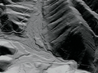
- WInSAR is a consortium of universities and research laboratories established by a group of practicing scientists and engineers to facilitate collaboration in, and advancement of, Earth science research using radar remote sensing.
GAGE has contributed to other projects & collaborations in the past, including:
- TEQC — Collaboration with GPS/GNSS equipment manufacturers and other institutions to provide a simple yet powerful and unified approach to solving many pre-processing problems with GPS, GLONASS, Galileo, SBAS, Beidou, QZSS, and IRNSS data, especially in RINEX or BINEX format.
- EarthScope — a collaboration with the other components of this major US science initiative, e.g. USArray at IRIS and SAFOD at Texas A&M University.
- EarthScope - Plate Boundary Observatory (PBO) — a component of the EarthScope project that precisely measured Earth deformation resulting from the constant motion of the Pacific and North American tectonic plates in the western United States.
- COCONet - Caribbean Network — an international geoscience community project to develop Caribbean-wide GNSS/GPS observations for geophysical and atmospheric hazard studies in the Caribbean region.
- TLALOCNet - Mexico Network — an international geoscience community project to develop Mexico-wide GNSS/GPS observations for geophysical and atmospheric hazard studies in Mexico.
- Supersites — an initiative under the auspices of the Group on Earth Observations (GEO) that provided access to space borne and in-situ geophysical data of selected sites prone to earthquake, volcano, or other hazards through a web site hosted at GAGE.
- SNARF — Stable North America Reference Frame
- ILP GSRM — Global Strain Rate Model sponsored by the International Lithosphere Project
- GEM GSRM — Global Strain Rate Model sponsored by the Global Earthquake Model (GEM) international forum
- BARGEN — Basin and Range Geodetic Network in the western US
- L1 Project — L1-only receiver & radio modem system for geo-hazardous sites
- SuomiNet — world-wide GPS and meteorological array
- GeoEarthScope — SAR. ALS, and geochronology datasets for EarthScope
- Seamless SAR Archive (SSARA) — NASA ROSES funded project to provide users with GUI and web service API to view and retrieve SAR data from multiple archives
Last modified: 2026-05-28 09:22:23 America/Denver