)
Index
Data
The NSF GAGE Facility (hereafter referred to as GAGE) operated by EarthScope Consortium promotes research by providing access to data that our community of geodetic scientists uses for quantifying the motions of rock, ice and water that are monitored by a variety of sensor types at or near the Earth's surface. After processing, these data enable millimeter-scale surface motion detection and monitoring at discrete points, and high-resolution strain imagery over areas of tens of square meters to hundreds of square kilometers. The data types include GPS/GNSS, SAR and Lidar/SfM, strain and seismic borehole data, and Tropospheric data. Most of these can be accessed via web services. In addition, GNSS/GPS data sets, TLS data sets, and InSAR products are assigned digital object identifiers. See our data help page to request support or custom data acquistion.
![]()
ICSU WDS Regular Member certification since 2015
GAGE archives datasets and derived data products collected by community investigators funded by a variety of sources.
The data user bears sole responsibility for adhering to the GAGE Data Policy and acknowledging the role of the data provider through co-authorship, citation, sponsor acknowledgment, and/or other attribution, as appropriate and consistent with professional standards and sponsor requirements.
GPS/GNSS data refer to raw measurements of GPS/GNSS signals logged by receivers at survey points, processed results of the raw measurements such as geodetic positions of survey points, or geologic velocities of those points.
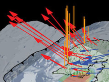
Geodetic imaging uses radar and laser data for tracking centimeter-scale motions at the Earth's surface over several square meters to hundreds of square kilometers.
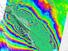
- Synthetic Aperture Radar (SAR) Data, such as Interferometric Synthetic Aperture Radar (InSAR), can be used to model millimeter-to-centimeter level displacements in the Earth's surface over scales of tens to hundreds of kilometers.

Lidar/SfM uses laser data and photography for tracking centimeter-scale motions at the Earth's surface over several square meters to hundreds of square kilometers.
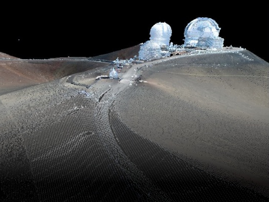
- Terrestrial Laser Scanning (TLS) Data are obtained from ground-based lidar (light detection and ranging) instruments that provide 3-D point measurements with millimeter-to-centimeter precision over scales of tens of meters to kilometers.
Strainmeters and seismometers record transient deformation signals with periods of milliseconds to months. Borehole data — strain, seismic, tilt, and pore pressure — yield information about the physical properties of the rock surrounding the borehole.
- Borehole Strainmeter Data (BSM) are collected from four-component deep-borehole tensor strainmeters.
Get BSM Data - Borehole Seismic data are collected by short-period, deep-borehole seismometers, most of which are co-located with borehole strainmeters.
Get Seismic Data
- Borehole Pore Pressure data at a 1-Hz sampling rate is available in ASCII-format files; there are no processed data products because the raw data can be used by users without modification. Get Pore Pressure Data
- Borehole Tilt data are collected by shallow-borehole tiltmeters, co-located with GPS or borehole strainmeter and seismic stations. Get Tilt Data
Tropospheric data are collected along with GPS/GNSS and other forms of geophysical data to enhance the datasets, contribute to network monitoring information, and provide additional information for interpretation of deformation signals.
- Surface Met Data from GPS/GNSS sites co-equiped with meterological sensors. Get Surface Met Data
- Tropospheric Processing Products are generated GAGE post-processing of daily GPS data.
- Integrated Precipitable Water Vapor (PWV) uses GPS Data from the NOTA Network operated by the GAGE Facility (formerly the PBO and COCONet networks), Suominet + NOAA, USCG/USACE, DOT, and other sites.

The GAGE Facility is working to provide unified access to our data using Web Services based on consistent interfaces and best practices. Some of these web services now include:
Last modified: 2026-05-28 09:22:21 America/Denver