

Project Support & Services
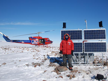
The NSF National Geophysical Facility (NGF) support and services groups provide comprehensive project technical support services to investigators using GNSS, TLS, and SAR data. These services range from loaned equipment, testing, configuration, integration, and new equipment designs for field deployments to technical training for campaign and permanent station deployments.
General Support
- Geophysical Event Response — NGF can help coordinate community field activities, hardware, and data requests following an earthquake, volcanic eruptions, or other notable geophysical events.
- Polar Services — provide support to NSF-OPP funded scientific investigators working in the Arctic and Antarctic.
- Development & Testing — ongoing instrument & equipment testing of GNSS receivers & antennae, communications systems, and power systems for various NGF projects.
- Data Management & Archiving does GNSS data delivery or pickup and conversion RINEX, long-term archive storage and FTP access of GNSS and SAR data.
- Education & Outreach Services — provides support for Broader Impacts planning and execution of PI projects.
GNSS
GNSS support for PI projects using GPS or full GNSS instrumentation and ancillary equipment, either as permanent stations or in campaign or kinematic surveying:
Imaging
- Terrestrial Laser Scanning (TLS) — Support for TLS projects, including TLS instrumentation and associated peripherals.
- Unmanned Aerial Systems (UAS) — Support for UAS projects, including UAS instrumentation and associated peripherals.
Borehole
Borehole Services — expertise for siting, permitting, drilling, grouted instrument installation at depth for 3-axis seismic, horizonal strain, tilt, and borehole pressure as well as borehole data collection and analysis.
Last modified: 2026-08-16 17:25:07 America/Denver