)
GeoEarthScope - ESA Cat-1 Proposal: GeoEarthScope InSAR Data for the Basin and Range Province
Details over data requirements
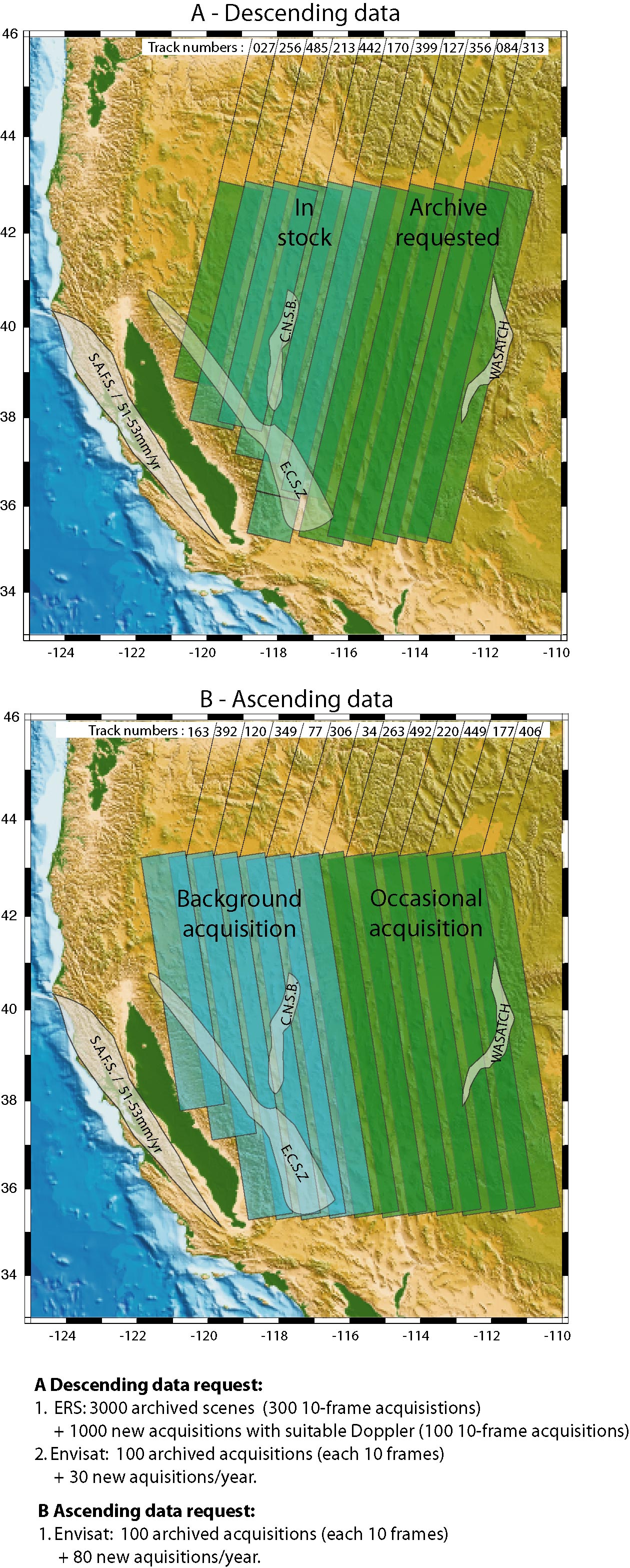
For an overview of data requirements see Fig. A. We request 1) nearly the entrie ERS archive for the eastern Basin and Range (300 acquisitions or 3000 frames) 2) the entire Envisat archive (200 acquisistions), 3) new Envisat acquisistions (110 acquisitions/year) and 4) new ERS acquisitions (10 acquisitions/year). Each acquisition (orbit or product) covers 10 frames.
Archived acquisistions:- ERS: A Descending orbits: For the Eastern Basin and Range we request a total of 3000 framed scenes for the 1992-2002 period (300 10-frame acquisitions).
- Envisat: All archived imagery for the Basin and Range (100 acquisitions)
- ERS: 2002-2010 imagery with Doppler centroid suitable for interferometry for the entire Basin and Range.
- Envisat:
- Descending orbits: We request 3 acquisistions per year for the entire Basin and Range (10 tracks) (total of 30 acquisitions/year)
- Ascending orbits: We request frequent acquisitions for the western Basin and Range (every 35 days, tracks 163, 392, 120, 349, 77, 306) and occasional acquisitions for the eastern Basin Range (2 acquisitions per year on each track). The acquisistions for the western Basin and Range have been added to the background acquisistion plan (Henri Laur, personal communications). Total number of acquisitions requested: 80 per year.
In summary, the data request until 2010 is:
ERS: 4000 scenes (3000 archived scenes (1992-2005) plus 1000 new scenes (2006-2010))
Envisat: 650 acquisitions (100 archived plus 550 new acquisistions (1000 plus 5500 scenes))
Imaging mode: We only request standard IS2 imagery because most scientific users in the U.S. are more comfortable with this imaging mode than with wideswath. The resolution of wideswath is too low to detect small-scale subsidence areas.
Last modified: 2026-05-28 09:22:23 America/Denver