
Polar Services - Antarctic - Meta-Data Summaries (2001/02 Season) - B-043 Bowser
| B-043 Bowser |
|---|
|
Data Set Name: B-043 2001/02 Investigator: PI: Samuel Bowser Institution: New York State Department of Health, Wadsworth Center POC: PI Email: http://www.members.global2000.net/bowser/ (bowser |
| Summary:
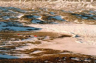
Dr. Bowser requested a survey of the New Harbor research area, where the field team studies the unique shallow water occurrence of agglutinated foraminifera, a dominant member of cold, deep-sea sediment ecosystems. GPS was used to obtain sub-meter positions of the shoreline at both high and low tide, and the perimeter of tidepools. UNAVCO provided field support, data processing, and data archiving for this project, which was performed with the Trimble 4700 receiver system in kinematic mode. The coordinates obtained will be used for mapping purposes and to determine changes in water volume between high and low tide. |
Last modified: 2019-12-24 02:12:41 America/Denver