)
2016 Short Courses Archive
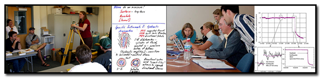
In response to community requests and interest, UNAVCO provides an annual series of short courses focussed on UNAVCO tools and data streams. These courses are for current researchers who want to refresh their skills or explore the use of new tools, and for early career scientists such as post doctoral fellows, graduate students, and upper level undergraduates who want to learn the latest geodetic techniques.
Short Course Materials
Course Materials from previous short courses.
2016 Short Course Information
(Courses are listed by topic then in chronological order)
Faculty Development Courses:
UNAVCO Early Career Geo-Resources for you & Your Teaching
Presented at A Career Development Workshop for NSF Geosciences Postdoctoral Researchers
Boulder, Colorado
March 11, 2016
More about the workshop
UNAVCO Presentation [pdf]-
Geodesy Data Teaching Modules: GETSI Short Course
Wednesday, March 30, 2016 from 1:00pm - 5:00pm
Location: Omni Interlocken Hotel in Broomfield, Colorado
This meeting will be held in conjunction with the 2016 UNAVCO Science Workshop -
Using TLS and Structure from Motion (SfM) Photogrammetry in Undergraduate Field Education
Dates: Tuesday August 16 - Friday August 19, 2016
Location: Indiana University Geologic Field Station, Cardwell, MT (in the Tobacco Root Mountains of southwest Montana)
Times: Course will begin at 6pm on August 16th, 2016 and end at noon on August 19th, 2016.
Optional afternoon of more surveying applications on August 19. GSA short course: 525. Introduction to Structure from Motion (SfM) Photogrammetry for Earth Science Research and Education
Course Materials
Sat., 24 Sept., 9 a.m.–5 p.m., CCC, Room 110
Cost: US$30, includes lunch. Limit: 40. CEU: 0.7
Instructors: Edwin Nissen, Colorado School of Mines; Ramon Arrowsmith, Arizona State Univ.; Christopher Crosby, UNAVCO
Cosponsor: UNAVCOAbstract: Structure from Motion (SfM), a photogrammetric technique that uses overlapping images to construct 3D surface models, is quickly emerging as a valuable research and education tool in geodesy, geomorphology, structural geology, and related disciplines. Images can be collected with a standard consumer-grade camera, making SfM a low-cost tool that compliments other 3D imaging technologies, such as terrestrial and airborne laser scanning (LiDAR). SfM can be collected from a hand-held camera or an airborne platform such as an aircraft, tethered balloon, kite, or UAS (unmanned aerial system), enabling 3D imaging of features ranging in size from decimeters to several kilometers. This one-day course will provide faculty, students, and professionals with an introduction to SfM technology, data collection and processing, and examples of science and educational applications. A combination of lectures and hands-on demonstrations of SfM equipment and data processing will be used.
-
Hooking undergraduates into geophysics data and methods (GPS, Lidar, InSAR, SfM photogrammetry) through societally important issues
Date: Sunday December 11, 2016
Location: American Geophysical Union Annual Meeting, San Francisco, CA
Times: Course will be 8 am-5 pm on Sunday December 11 (lunch included)
InSAR Courses:
-
InSAR Theory & Processing with ISCE, GIAnT, and StaMPS
Dates: Monday August 1 - Friday August 5, 2016
Location: UNAVCO, Boulder, Colorado
Times: Course will begin at 8:00 am on August 1 and end at 12 noon on August 5.
Registration is closed -
InSAR Processing and Theory with GMTSAR: Sentinel-1A Time Series
Dates: Wednesday August 10- Friday August 12, 2016
Location: Scripps Institution of Oceanography, La Jolla, CA
Times: Course will begin at 9 AM on August 10 and end an 12 PM on August 12.
Registration is closed -
COMET InSAR Training Workshop
Date: Monday October 31, 2016 - Wednesday November 2, 2016
Location: School of Earth and Environment (SEE), University of Leeds, Leeds LS2 9JT, United Kingdom
Description: Three-day workshop aimed at early postgraduate and postdoctoral researchers that will include a combination of lectures and practical exercises covering topics including but not limited to InSAR theory, SAR data preparation and processing, and displacement field modelling.
Laser Scanning Courses:
-
Imaging and Analyzing Southern California's Active Faults with High Resolution Topography
January 25 - 26, 2016
Location: Arizona State University, Tempe, Arizona
A Joint SCEC, OpenTopography, UNAVCO and EarthScope short course
Open Source ALS and MLS Processing Tools
Wednesday, March 30, 2016 from 1:00pm - 5:00pm
Location: Omni Interlocken Hotel in Broomfield, Colorado
This meeting will be held in conjunction with the 2016 UNAVCO Science Workshop
Imaging and Analyzing Active Faults with High Resolution Topography
Monday April 18 - 19, 2016
Location: UNAVCO, Boulder, Colorado
Times: Course will begin at 8 AM on April 18, followed by an evening program and end at 5pm on April 19. GSA Short course: 501. Introduction to Terrestrial Laser Scanning (Ground-Based LiDAR) for Earth Science Research and Education
Course Materials
Fri., 23 Sept., 8 a.m.–5 p.m., UNAVCO, Boulder (A bus will be provided from the Colorado Convention Center)
Cost: US$50; lunch included. Limit: 20. CEU: 0.8
Instructors: Christopher Crosby, UNAVCO; Marianne Okal, UNAVCO
Cosponsor: UNAVCOAbstract: This one-day course will provide faculty, students, and professionals with an introduction to terrestrial laser scanning (TLS, also known as ground-based LiDAR). TLS provides high-resolution 3D images of geologic features and has emerged as a powerful tool for applications ranging from outcrop mapping to analysis of earth surface processes. The course will focus on TLS technology, data collection, processing and analysis, and examples of science and educational applications. A combination of lectures and hands-on demonstrations of TLS equipment and data processing will be used.
Strainmeter Courses:
-
Working with Strainmeter Data
Monday, March 28, 2016 from 8:00am - 5:00pm
Optional data viewing on Thursday, March, 31, 2016 from 1:00pm - 5:00pm
Location: Omni Interlocken Hotel in Broomfield, Colorado
This meeting will be held in conjunction with the 2016 UNAVCO Science Workshop
Teacher (Grades 6 - 12) and Park Ranger & Interpreter Development Courses:
- GPS and Earthquake Early Warning [youtube]
- What can GPS tell us about future earthquakes? [youtube]
- Beauty and the Beast: Plate Tectonics and Geological Hazards of the Pacific Northwest
- Basics of Earthquake and Tsunami Science and Hazards and Related Teaching Activities[pdf]
- Cascadia Earthquakes and Tsunami and Related Teaching Activities [pdf]
- World Map of Plate Boundaries and Activity[pdf]
- Pacific Northwest Tectonic Block Model[pdf]
- Activity—Cascadia GPS (gumdrop GPS)[pdf]
- Advanced GPS Activity—Locked & Loading [pdf]: Using Plate Boundary Observatory (PBO) data to determine elastic compression of the Pacific Northwest Active Continental Margin.[pdf]
- Activity—ETS (Episodic Tremor & Slip) [pdf]
- Local GPS cards illustrating the change of position over time for Quillayut , WA and Aberdeen, Washington, Goldendale, Washington, Astoria, Oregon , Newport, Oregon, Cape Meares, Oregon , Corvallis, Oregon [pdf]
- Relevant Next Generation Science Standards[pdf]
- Webinar presentation slides: UAVs 4 STEM [pdf]
- Webinar presentation slides: Plan, Fly, Review: Documenting Drone Data [pdf]
- NSTA Presentation: Using Recreational UAVs (Drones) for STEM Activities and Science Fair Projects [pdf] [pptx]
- eBook draft: “Got a Drone? Try This! Learning Activities and Science Fair Project Suggestions for You and Your Recreational Drone” [pdf]
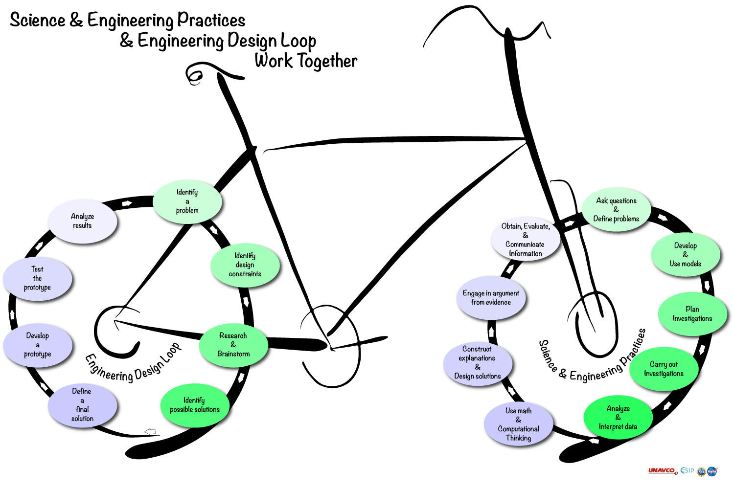
- Diagram illustrating Science & Engineering Practices and Engineering Design Principles working together [pdf]
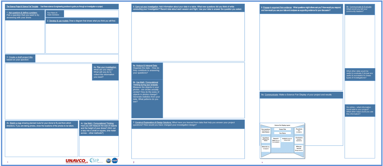
- Student template for developing a science fair or sciece project using NGSS Science & Engineerging Practices [pdf]

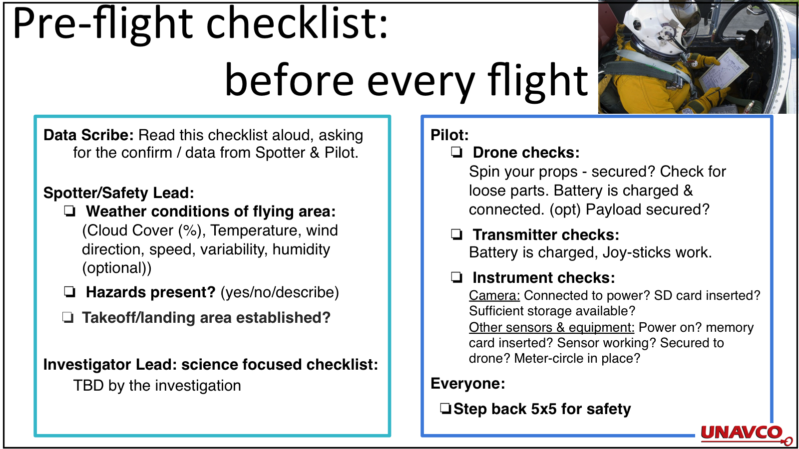
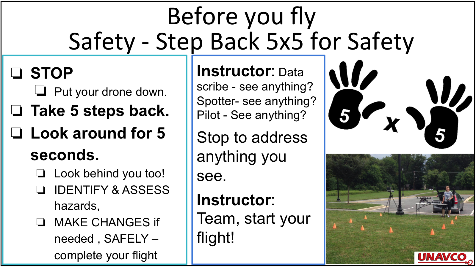
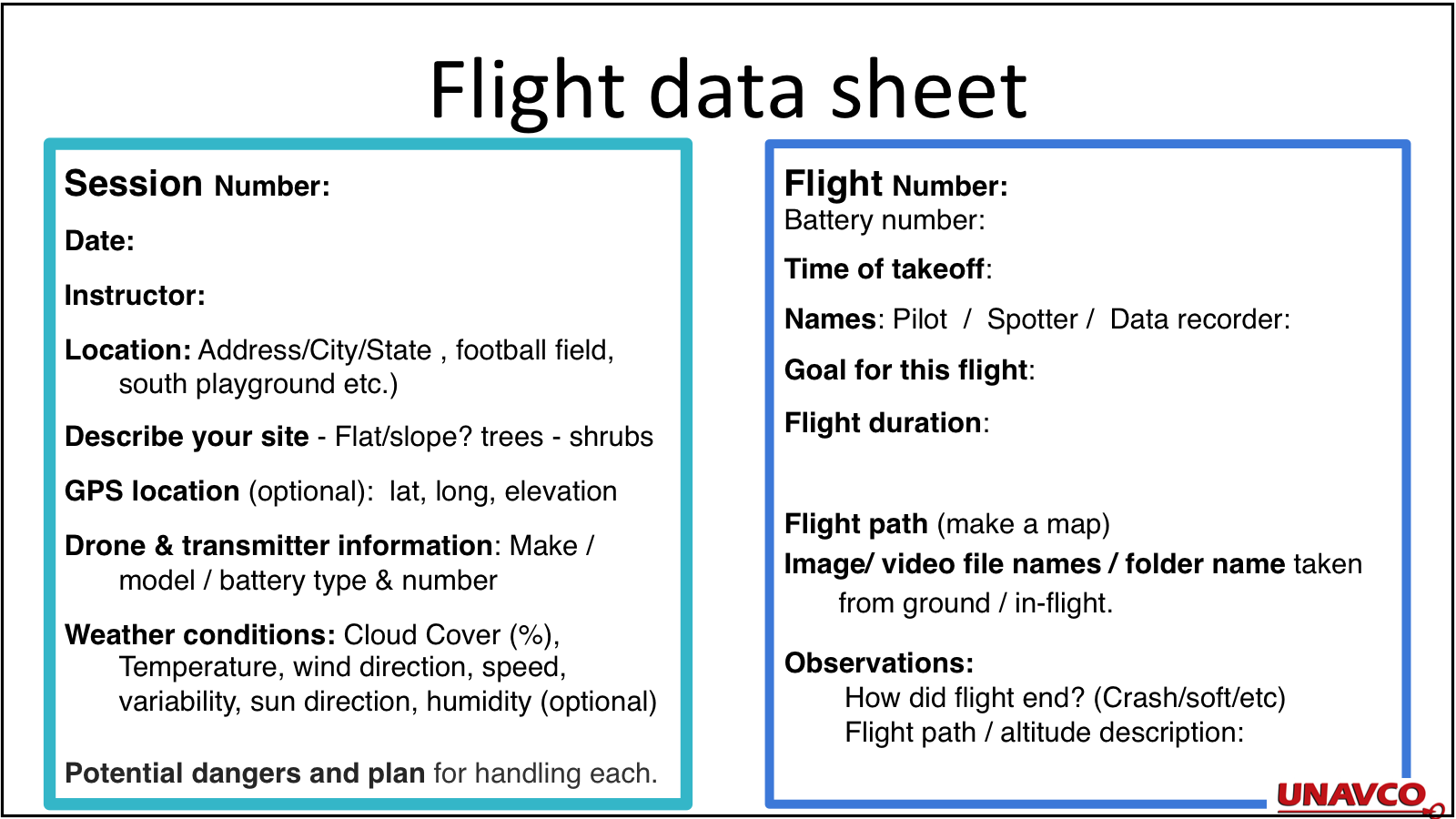
- Checklists for pre-flight, before you fly: safety - step back 5x5, steps for take off & during flight, and sample flight data sheet [pdf]
- About UNAVCO (Explained in 3 Minutes) [youtube]
- Looking Down a Well: A Brief History of Geodesy [youtube] - NASA
- Exploring Tectonic Motions using GPS Velocity Maps
- GPS Velocity Map Posters: Including "Tectonic Motions of the Western United States" and "Tectonic Motions of Alaska"
- NSTA STEM Forum & Expo: July 27–29, 2016
Denver, CO
July 28, 2016 - NSTA Area Conference: Minneapolis, Minnesota
Friday, October 28, 2016 - NSTA Area Conference: Portland, Oregon
Workshop and NESTA Share-a-Thon @ NSTA
Friday, November 11, 2016 - NSTA Area Conference: Columbus, Ohio
Dec 1, 2016 - About UNAVCO (Explained in 3 Minutes) [youtube]
- Looking Down a Well: A Brief History of Geodesy [youtube] - NASA
- Exploring Tectonic Motions using GPS Velocity Maps
- GPS Velocity Map Posters: Including "Tectonic Motions of the Western United States" and "Tectonic Motions of Alaska"
- About UNAVCO (Explained in 3 Minutes) [youtube]
- Exploring Tectonic Motions using GPS Velocity Maps
- GPS Velocity Map Posters: Including "Tectonic Motions of the Western United States" and "Tectonic Motions of Alaska"
Seattle-Tacoma Teachers - Earthquake Science and Preparedness Workshop
Part of the Cascadia Earthscope Earthquake and Tsunami Education Program (CEETEP) Workshop series
Workshop for middle-level science teachers from Seattle-Tacoma area
CWU Des Moines Center on the Highline Community College campus, Washington
Saturday, February 27, 2016 -- 9 am-5:30 pm
This workshop was funded primarily by Puget Sound Energy Foundation. Through a grant from the EarthScope Program of the National Science Foundation (NSF), CEETEP offers four-day workshops to foster community engagement of earthquake science and preparedness, and to encourage collaboration and exchange between formal and informal coastal educators and includes Pacific Northwest tectonics, earthquake and tsunami hazards, and community preparedness.
Relevant workshop resources with geodetic content:
Workshop series: UAVs in STEM Education: Using drones for science, technology, engineering, and math (STEM) investigations
A collaboration between education professionals at UNAVCO, NASA, NOAA, CIMMS, and other organization has resulted in the the Drones in STEM education initiative with the Earth Science Information Partners (ESIP) to promote Science, Technology, Engineering, and Math (STEM) through data-focused activities and modules.
During the workshops, educators learn how to facilitate STEM (Science, Technology, Engineering, Art and Math) investigations through hands-on experience, discussions, activities and interactions about the application of drones and apply this to using recreational drones in clubs, classrooms, and / or science fairs. Participants also learn about ESIP projects and partner organizations that provide learners with opportunities to apply skills in acquiring and using data.
Through this initiative, UNAVCO has been disseminating UNAVCO GAGE educational materials. Geodesy is interwoven into workshops by laying the foundation for students to learn about geodesy and structure from motion imagery, reference frames, data collection, science and engineering practices for research investigations and design principles, and research and experimentation using lightweight and inexpensive instruments and GPS modules.
Workshop and Webinar resources
Geodetic resources
Webinar & Workshop list:
UAVs 4 STEM: Drones in STEM Education Webinar
March 22 at 4:00 p.m. EST
Presenters: LuAnn Dahlman, NOAA, Dan Zalles, SRI
Authors: Presenters: LuAnn Dahlman, NOAA, Dan Zalles, SRI, ShelleyOlds, UNAVCO
More about the webinars
Plan, Fly, Review: Documenting Drone Data: Drones in STEM Education Webinar
April 26 at 4:00 p.m. EST
Presenters & Authors: Shelley Olds, UNAVCO; LuAnn Dahlman, NOAA
Testing & Polishing STEM Activities for Recreational Drones
Educator’s workshop @ 2016 ESIP Summer Meeting
Durham, North Carolina
Tuesday, July 19
ESIP Educators Workshop Agenda
Using Recreational UAVs (Drones) for STEM Activities and Science Fair Projects Workshops
National Science Teacher Association Area Conferences
Tectonic Motions of the Western United States
Colorado Science Conference
Location: Denver, Colorado
Date: November 18, 2016
Education workshop to teach ed professionals about Tectonic Motions of the Western United States and Alaska.
Geodetic resources shared in workshops
GIFT Shareathon
Geophysical Information for Teachers (GIFT) Workshops
San Francisco, CA
December 12, 2016
2016 agenda and workshop materials
UNAVCO Contributions:
Last modified: 2019-12-24 01:25:49 America/Denver