
This summer we’re introducing interns in the RESESS, Geo-Launchpad, and USIP programs to shine a spotlight on the research projects they are completing throughout these 11-week internships and on their interests in geoscience.
Michela Savignano will graduate with her bachelor’s degree in geochemistry from Brown University this December. She began college studying neuroscience and on the track to attend medical school. After her freshman year, Michela studied abroad at the University of Edinburgh in Scotland, where she was unable to take the required pre-med courses. She chose to take a variety of courses that sounded interesting, instead, including one called “Glacial Processes and Geomorphology” because it would allow her to go on a field trip to the Scottish Highlands. Through this course, Michela fell in love with Earth science and glaciology. She has since worked on a statistical and geospatial project about methane emission in Arctic waters at her home university. Michela’s advisor from Brown University sent her information on the program and she was excited to explore new research techniques.
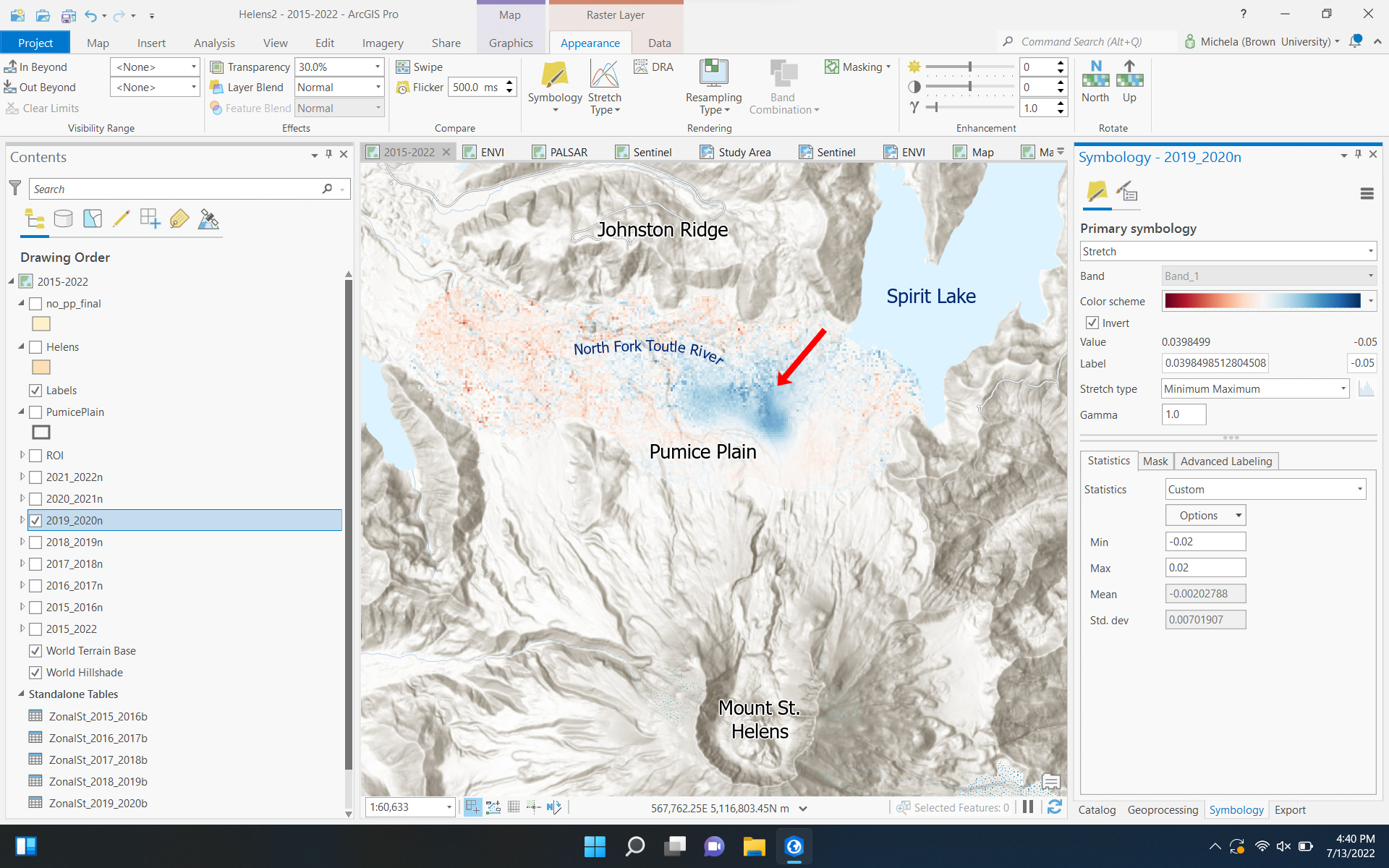
Michela is using satellite interferometry (InSAR) this summer, under the guidance of mentor Dr. David Schmidt at the University of Washington, to investigate subsiding land near Mount St. Helens. When Mount St. Helens erupted in 1980, the pyroclastic flows from the eruption deposited a 6-square-mile Pumice Plain north of the volcano. Michela is researching a portion of land within the Pumice Plain where surprising subsidence has been observed. By using a variety of satellite imagery from Envisat, ALOS PALSAR, and Sentinel, Michela can study multiple radar images of the same region taken at different times to analyze the changes in Earth’s surface. She is building a time series of the Pumice Plain’s subsidence, which will also allow her to calculate the rate of subsidence and determine if it has changed over time. Hopefully with this information, Dr. Schmidt and Michela will be able to hypothesize about what is causing this subsidence.
One goal of this research is to test the viability of utilizing Sentinel data to create a time-series that depicts changes throughout a year instead of just annual differences. Additionally, Michela’s research project will help scientists better understand volcano hazards and how the surrounding landscape continues to evolve even decades after an eruption.
Q&A:
- What has been your favorite part of the RESESS program so far?
I really like getting to work with…remote sensing and radar data. That’s something that’s totally new to me, so I really like that. Having a mentor, one-on-one, I’m able to learn a new skill. It’s not just, “Go off and figure it out yourself.” [Dr. Schmidt] has been working with me to teach me how to do it. I think that’s really cool. You don’t always get that kind of supervision and one-on-one instruction. I really appreciate it.
- What have you gained from your mentorship with Dr. Schmidt?
I think kind of what I touched on earlier about learning new skills and actually being sort of coached in a one-on-one [setting]. If I have questions, he’s so nice and willing to help me. I don’t feel any hesitation about saying, “This really doesn’t make any sense to me.” He’ll walk me through it and draw a diagram. I think that’s been really cool.
- Have you learned about any new topics/research techniques that have really piqued your interest?
Definitely the InSAR stuff that I’ve learned… I took a remote sensing course this past spring, so I’ve done some remote sensing-type work, but mostly with imagery, like Landsat imagery. I think learning to work with the radar data was a really cool technique.
Michela is hoping to pursue graduate school for glaciology and hopes to go into academia, so that she can continue teaching geoscience. This summer, she’s looking forward to spending time with friends and hiking throughout New England.

