Stable North America Reference Frame (SNARF)
Working Group Chair - Geoff Blewitt

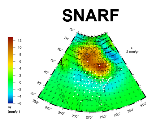
SNARF 1.0 GIA velocity field derived by a data assimilation approach.
The Plate Boundary Observatory (PBO) component of EarthScope used the science of geodesy to measure the slow deformations in the Earth's crust that are driven by plate tectonics and magmatism. Specifically, the Global Positioning System (GPS) is used to measure the movements of more than 1000 points spanning the North America-Pacific plate boundary. These motions must be defined relative to a terrestrial reference frame. Such a frame requires the definition of its Cartesian coordinate axes (including origin, orientation, and scale) and the evolution of these axes in time, as well as precise models of the dynamic Earth. The motions of the Earth's surface due to tectonic processes the region spanning the North America-Pacific plate boundary (the focus of PBO) are most naturally expressed with respect to the stable interiors of either the North America or Pacific plates. A standard reference frame therefore makes it easier to interpret the geodetic data in terms of where the total budget of relative plate motion is being accommodated (for example, how much deformation can be inferred to be offshore?), and how deeply the plate boundary dynamics penetrate into the plate interior (is the Rio Grande Rift in New Mexico still active?). A common reference frame also provides a simple way to compare results from different analysis groups.
For these reasons, UNAVCO formed the Stable North American Reference Frame (SNARF) working group to define the reference frame to be used for PBO. A series of several small NSF-funded workshops were held to develop SNARF and to educate the community about it. The SNARF working group was comprised of approximately a dozen geodesists with expertise in both developing and testing reference frames. The SNARF working group had significant links to developers of the International Terrestrial Reference Frame (ITRF), the national geodetic surveys of the U.S. (NGS), Canada (NRCan), and the geospatial community (CSRC) who had committed experts to collaborate with the university research community toward this effort.
- Products
- A reference frame for PBO: What do we have; what do we need? [ppt]
- SNARF
working group
- Workshops and Presentations
- 2005 Proposal [pdf]
- 2003 Proposal [pdf]
- NSF Reports
- References from the SNARF Working Group
- SNARF 1.0 Release
Last modified: 2019-12-24 02:12:54 America/Denver

