
GeoEarthScope
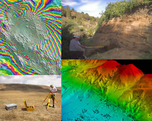
GeoEarthScope was a part of the EarthScope Program which included the acquisition of aerial and satellite imagery and geochronology to examine the strain field beyond the decade time scales available from the EarthScope - Plate Boundary Observatory (PBO) geodetic instrumentation. A goal of EarthScope is the improved understanding of the tectonic evolution of the North American continent. Identifying and understanding deformation rates in all tectonic regimes is critical to reaching that goal. UNAVCO provided support for GeoEarthScope related imaging and geochronology activities.
GeoEarthScope MREFC activities operated by UNAVCO concluded successfully on 30 Sept 2008. An overall summary of accomplishments is as follows:
SAR Data for InSAR Imagery: Synthetic aperture radar (SAR) data suitable for interferometric analyses were ordered from data provider catalogs, spanning the period from 1992-2008 and covering all of the western U.S. as well as parts of Alaska, Hawaii, and regions in the eastern and southern U.S. The GeoEarthScope catalog contains 16.5 TB of select SAR datasets co-located to UNAVCO SAR archive from the Alaska Satellite Facility (ASF) and the European Space Agency (ESA):
- ERS1: 1.7 TB from ASF, 0.6 TB from ESA
- ERS2: 3.4 TB from ASF, 1.9 TB from ESA
- Envisat: 1.1 TB from ESA
- RSAT1: 8.4 TB from ASF
Airborne LiDAR Imagery: Data acquisition campaigns took place in 2007 and 2008 and cover a total area of nearly 5,000 square kilometers. General maps of GeoEarthScope LiDAR coverage and Google Earth files showing detailed coverage by target region are available. All NoCal data are processed and available as Google Earth hill-shade files or ARC binary DEM files from OpenTopography.
Geochronology: Twelve geochronology laboratories received GeoEarthScope funds in 2007 to provide geochronology services to investigators independently identified and supported by NSF via the standard proposal process. For the list of supported labs and available services please refer to the following FAQ.
- New EarthScope airborne LiDAR data: SoCal and ISB [2009 September 15]
We are pleased to announce the availability of new EarthScope airborne LiDAR data products from Southern California and the Intermountain Seismic Belt (ISB):
- New SoCal data: Elsinore fault, Burro Flats segment of San Andreas fault, and southern Owens Valley including Crater Mountain. These are now available as hillshade images that can be viewed in Google Earth and as standard 0.5 m DEM tiles.
- Expanded SoCal data: for the Garlock fault, Point Cloud data are now available in addition to the previously released in KMZ and DEM formats.
- New ISB data: Wasatch Nephi North data now available as Google Earth hillshades, standard DEM tiles, and point cloud data. In addition, the point cloud for the rest of the ISB dataset, released previously in Google Earth and DEM formats, is now available.
Like the rest of the GeoEarthScope LiDAR dataset, these products are freely available from the OpenTopography portal in the following formats:
- Google Earth hillshades. The easiest way to explore this dataset, users can view filtered ("bare earth") hillshade images within Google Earth from two different illumination angles. The hillshade KMZ file is available for downloaded at http://opentopo.sdsc.edu/lidar?format=ge.
- Standard DEM tiles. For more advanced applications, filtered ("bare earth," fg*) and unfiltered (ug*) 0.5 m resolution digital elevation models in Arc Binary grid format are also available for download as 1 km^2 tiles. Users can browse and download the available data via an interactive map available at http://opentopo.sdsc.edu/lidar?format=sd.
- OpenTopography also provides access to raw point cloud data and and web-based tools to process these data into custom DEM products: http://opentopo.sdsc.edu/lidar.
- Intermountain Seismic Belt (ISB) LiDAR Project [2009 May 7]
We are pleased to announce the availability of new GeoEarthScope airborne LiDAR data products from the Intermountain Seismic Belt (ISB) project! This release includes high resolution LiDAR topography data collected in tectonically active regions of Utah and Wyoming, including Yellowstone and Grand Teton National Parks and the Nephi segment (southern strand) of the Wastach fault. These LiDAR data can be explored and downloaded in several ways:
- Google Earth. The easiest way to explore this dataset, users can view unfiltered (with vegetation) and filtered ("bare earth") hillshade images within Google Earth from two different illumination angles. The hillshade KMZ file is available for downloaded at http://opentopo.sdsc.edu/lidar?format=ge.
- GIS. For more advanced applications, filtered ("bare earth," fg*) and unfiltered (ug*) 0.5 m resolution digital elevation models in Arc Binary grid format are also available for download as 1 km2 tiles. Users can browse and download available tiles via an interactive map available at http://opentopo.sdsc.edu/lidar?format=sd.
Additional ISB LiDAR data products will become available in the coming months, including coverage of the northern strand of the Nephi Segment of the Wasatch Fault, as well as point cloud access and custom DEM generation capability for all ISB coverage using GEON developed cyberinfrastructure. A metadata document for this project is also currently in preparation.
We would like to thank the National Park Service, with special thanks to the Geology, GIS and fire cache personnel at Yellowstone and Grand Teton national parks, for their support and collaboration.
GeoEarthScope Working Group Reports:
- GeoEarthScope Review Panel report [PDF - 94KB]
- InSAR [PDF - 27.8MB]
- LiDAR [PDF - 11.6MB]
- Geochronology [PDF - 2.5MB]
Last modified: 2019-12-24 02:12:57 America/Denver