)
PBO GPS/GNSS Campaigns
UNAVCO maintained 100 campaign GPS systems in order to support portable GPS deployments funded by the NSF's EarthScope Science panel. Based on Topcon GB-1000 equipment, the systems were designed for stand-alone temporary or semi-permanent deployment that was used for densifying areas not sufficiently covered by continuous GPS and for responding to volcanic and tectonic events. UNAVCO provided support for all aspects of these projects, including proposal and budget development, project planning, equipment, field support, training, and data archiving.
Each portable self-contained campaign system included a low-power Topcon GB-1000 GPS receiver and antenna, 18 Ah batteries, and a regulated 32 watt solar charging system in a waterproof case with security enhancements. The receivers had 1 GB each of internal and redundant external memory sufficient for storing over a year's worth of data, as well as IP and serial communications capabilities for longer-term deployments. Monumentation options were determined on a project-by-project basis, with options including Tech2000 masts, low-profile spike mounts, and traditional tripods and optical tribrachs. Six of the 100 systems were equipped with real-time kinematic (RTK) capability for such uses as rapid fault mapping and GIS-based geologic mapping.
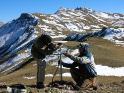
UNAVCO field engineer Jay Sklar and technician Michael Barton of the Center for Snow and Avalanche Studies mount the GPS antenna at station RG20 near Silverton, Colorado. This site is one of 24 semi-continuous GPS stations installed in Colorado and New Mexico to measure deformation across the Rio Grande Rift. For more information, see the Rio Grande Rift project homepage.
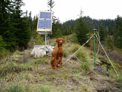
GPS station BIVO, installed in March 2005 near Mt. St. Helens, was the first use of the UNAVCO-supported Topcon GB-1000 equipment pool. The Tech 2000 antenna mast, consisting of a single vertical rod located over a control point and held in place by three chains bolted to the ground, was used for antenna monumentation.
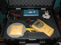
EarthScope GPS/GNSS Campaign system prototype. Clockwise from top-center: 18 Ah 12 volt battery, optical tribrach, Topcon GB-1000 GPS receiver, Topcon antenna, solar charge regulator. An optional metal security bracket locks around the case.
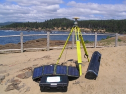
Investigators at the University of Oregon operated a two-week UNAVCO-supported GPS/GNSS Campaign on the Oregon Coast to complement tide-gauge and leveling measurements of the regional vertical deformation field. A Topcon GB-1000 GPS receiver, solar charge regulator, and 18 Ah battery are protected within the waterproof case.
Last modified: 2026-03-09 18:06:37 America/Denver