

2021 USIP Intern Becca Bussard 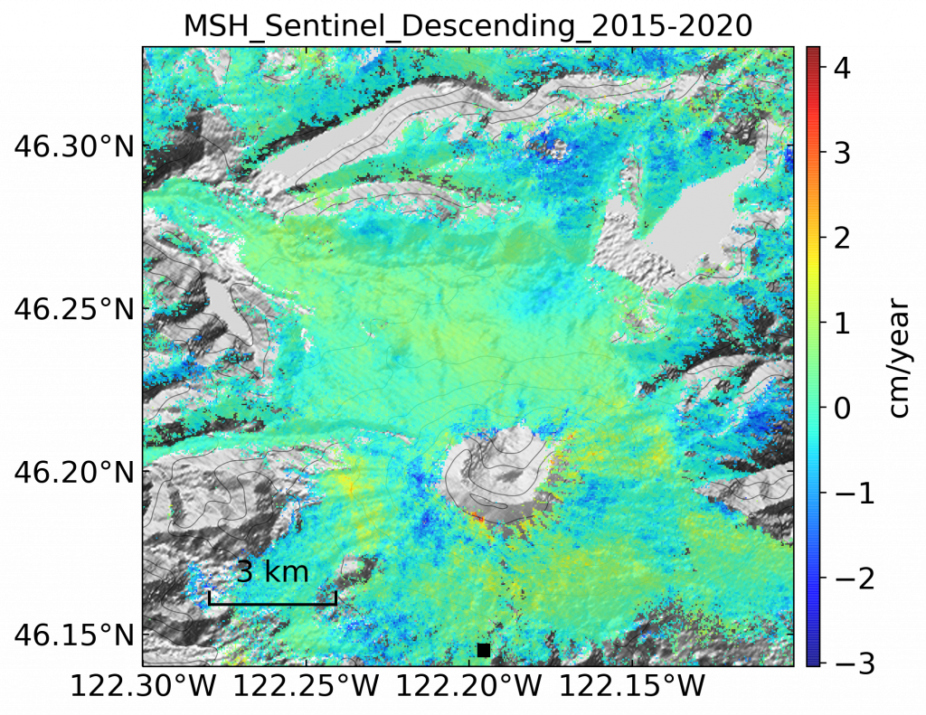
Velocity map over Mount Saint Helens created by USIP intern Becca Bussard with Sentinel data for her doctoral research.
This summer we’re introducing interns in the RESESS, Geo-Launchpad, and USIP programs to shine a spotlight on the projects they are completing throughout these 11-week internships and on their interests in geoscience.
Rebecca (Becca) Bussard is entering her third year as a PhD candidate at the University of Oregon. She uses satellite geodesy, specifically Interferometric Synthetic Aperture Radar (InSAR), to measure the surface deformation of Earth. Becca is able to utilize the deformation signals to understand surface and subsurface processes occurring at volcanoes and how these processes impact the signal InSAR retrieves. She also uses GPS data in her work to compare with the InSAR data she processes, as well as multispectral optical data.
Becca has been a big fan of volcanoes since she was young. She did not have the chance to explore Earth science much in high school, so she entered her undergraduate career as a physics major at Pennsylvania State University. In her sophomore year, she took a course called “Hollywood vs Reality: Natural Disasters”, in which the class watched various movies about natural disasters and then explored the feasibility of the events in the movies. The students would complete basic computations to answer questions like, “Could these people have actually outrun this volcanic eruption?” and “Is it realistic that this hurricane is the size depicted in the movie?” Becca had a lot of fun in this course, and learned that her professor, Dr. Christelle Wauthier, had a PhD in geophysics. This was the first time that Becca had heard of the geophysics field and it piqued her interest. She spoke to Dr. Wauthier to learn more about the subject and her professor invited her to join her lab, introducing Becca to InSAR for the first time. Becca continued with InSAR research throughout her junior and senior years of college as well, utilizing the technique to examine Telica, a volcano in Nicaragua. Because of these geoscience research experiences, Becca decided to major in physics and minor in geophysics, and Dr. Wauthier encouraged her to attend graduate school.
Becca was somewhat familiar with UNAVCO prior to the internship, mostly because of the short courses that they offer. When UNAVCO announced an internship position for someone who specialized in InSAR, Becca felt like her skillset fit the needs of the position perfectly. After completing her comprehensive exams this year, she also thought that a small break from research might be what she needed. Lastly, she wanted the opportunity to network with and meet people who specialized in geodesy.
Mentored by UNAVCO’s Chris Crosby and Matt Beckley, Becca’s overarching goal this summer is to clean up the SAR material hosted on UNAVCO’s website and YouTube pages. Although UNAVCO hosts many different tools for SAR analysis, the documentation for the resources needed to be updated. Becca has already created several tutorials for using InSAR that cover the basics of the software, and she plans to make additional videos throughout the summer. She is also adding information to the SAR pages on UNAVCO’s website (coming soon!) and improving the documentation for the InSAR Processing and Theory Short Course that UNAVCO is hosting. Becca and her supervisors hope that her work this summer will allow InSAR to be more accessible and understandable for users.
Q&A
- What has been your favorite part of the USIP program so far?
I made tutorials for how to use one of the scripts that UNAVCO or WInSAR houses. Essentially, I made tutorials of how to use this script and also how to use the interface associated with it… It was really nice because I use it for my research anyway, and one of the big things with InSAR is that it’s just a lot of coding and it’s a lot of software. It can be really intimidating if you don’t have any experience with it or with coding in general. I really would like to see more people understand how to interpret InSAR and also how to process it themselves. It seems that as more people use InSAR, more Earth science applications of it are discovered.
If I hadn’t had my lab at Penn State, I would look at InSAR and be like, “No, that’s too much software usage.” So making those tutorials and also hopefully making tutorials for some of the other software has been really fun, getting in that headspace and actually saying, “I do know how to use this, so I can show other people and hopefully describe it in a way that makes it easier for them to use.” I think the way that science is moving in terms of big data, remote work, and things like that, I think InSAR is going to become a huge tool, and I think if you know how to use it, it’s going to be really beneficial. From what I’ve seen, remote sensing is becoming vital in Earth Science, so helping people understand the one remote sensing technique I’ve become familiar with is important to me.
- What have you gained from your mentorship with Chris Crosby?
It’s been nice to have a mentor that specializes in geodesy and is familiar with SAR. Given that the field is relatively young, there still aren’t many people that use geodesy, so being able to discuss the field with someone else who specializes in it has been fantastic. It’s a bit nice to just be able to interface with someone in the community and get a chance to talk to him about remote sensing, and even though he does more LiDAR than InSAR, he has a pretty good understanding of who to talk to when I need help. He also put me in contact with the people at WInSAR and they’ve been very helpful and supportive. I think that’s been the main thing, just getting to meet and interact with so many people in the geodesy community has made me feel very supported and excited to explore more of the field.
- How does this internship fit into your future goals or help you achieve them?
This internship has caused me to have a very good understanding of the software I use for processing my data, since if I’m going to explain the code to people I should actually know what I’m talking about. That has been nice because sometimes with code, you know it well enough to the point that you know what works and then you don’t want to break it or touch it any further. You’re just like, “Okay, well, it works.” This summer, I’ve been forced—but I’ve also enjoyed—delving into it and almost finding out how to break it. That way I know the limits of it. That’s been fun because whenever I am forced to do that, I actually get more comfortable with coding in general. That’s been a fun aspect to do career-wise—forcing myself to get more accustomed to software, because I think that’s where it’s headed.
Also, just from a logistical standpoint, having small deliverables. I think in a PhD, you have such grand goals of getting data and publishing a paper and eventually writing your dissertation, and it’s kind of nice to do smaller tasks week by week… Regardless of if I go into academia or industry, I feel like being able to achieve small goals on a shorter timeline is equally important as those grander, bigger goals that you also have to think about.
After obtaining her PhD, Becca plans to complete a post-doctoral fellowship. She really likes the possibilities of teaching and mentoring that are associated with academia, but also finds herself interested in the industry jobs that are available. Regardless of whether she decides to pursue academia or industry, Becca is hoping to continue her research in geodesy, particularly InSAR. This year, she is taking some GIS courses to improve her computing skills, so she is well-equipped for any career path. This summer, Becca has been exploring Oregon and is looking forward to visiting her family in Pennsylvania for several weeks.
Written by:
- Lucia Bellino, USIP Intern
- Posted: 28 July 2021
- Last updated: 26 July 2021
- Tags: internships, SAR
-

