
Event Response to the July 22, 2020 M 7.8 Simeonof, Alaska Earthquake
The Simeonof M7.8 earthquake occurred on July 22, 2020 near the mostly uninhabited Shumagin Islands. The earthquake ruptured a portion of the Aleutian subduction zone that has not hosted an earthquake in over 100 years. Shaking was felt as far as 500 miles from the epicenter. No significant damage was reported.
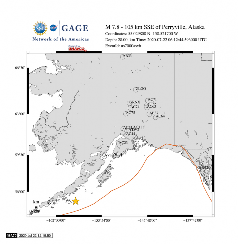
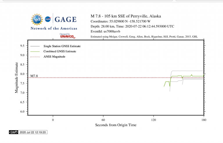
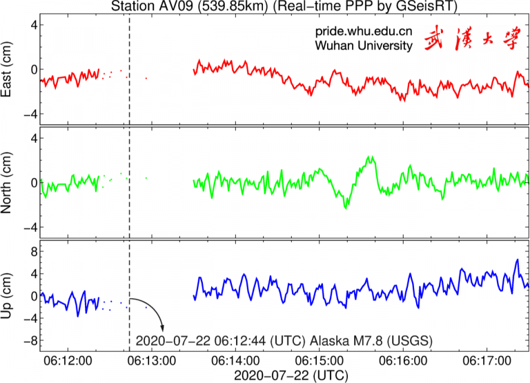
A magnitude 7.8 earthquake occurred at 06:12:44 UTC (22:12:42 local) on July 22, 2020, 105 km SSE of Perryville, Alaska. The earthquake is referred to by the Alaska Earthquake Center as the Simeonof earthquake. For more information, see the USGS Earthquake Hazards Program event page or the Alaska Earthquake Center event page.
The event occurred within the Network of the Americas (NOTA) footprint. NOTA is a core component of the NSF Geodetic Facility for the Advancement of Geoscience (GAGE), operated by UNAVCO.
Figures and findings are preliminary and subject to revision.
Acknowledgements
These data are provided by the GAGE Facility, operated by UNAVCO, Inc., with support from the National Science Foundation and the National Aeronautics and Space Administration under NSF Cooperative Agreement EAR-1724794. The Network of the Americas (NOTA) is a core component of the NSF GAGE Facility. To acknowledge use of these data please follow the acknowledgment guidelines.
Did you feel it?
The USGS collects information from people who felt an earthquake and creates maps that show what people experienced and the extent of the damage
Submit a responseHOME
Written by:
- Kathleen Hodgkinson, Dave Mencin, Beth Bartel & Andi Ellis
- Posted: 22 July 2020
- Last updated: 7 November 2022
-


Did you feel it?
The USGS collects information from people who felt an earthquake and creates maps that show what people experienced and the extent of the damage
Submit a responseOn this page:
RESPONSE DATA
Please contact archive-gps@unavco.org for information on data availability. To request access to these and other RT-GPS stations operated by UNAVCO please send an email request to rtgps@unavco.org.
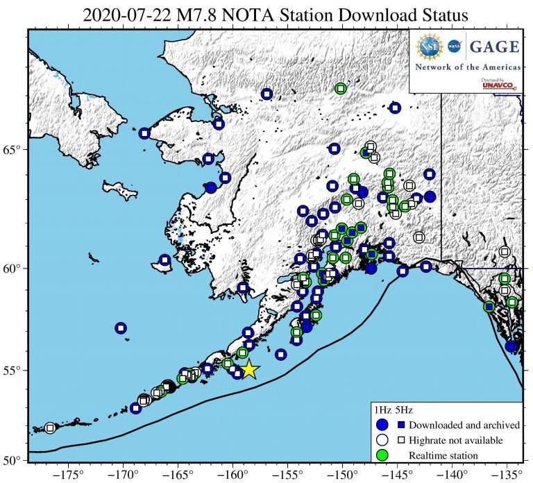
NOTA GPS/GNSS Real Time Data Solutions
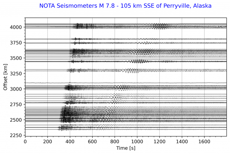
There are 41 real-time-enabled GPS/GNSS stations within 1550 km of the epicenter. Real-time stations continuously stream high rate (1-sps / 1 Hz) data to UNAVCO. Typical latencies for real-time stations, the time lapse between and observation being recorded on the receiver and it arriving in Boulder are less than 1 second. The radius is based on 2 cm predicted dynamic displacements.
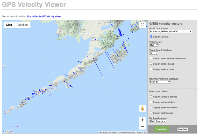
NOTA GPS/GNSS Data
GNSS data access tools can be found here. The Event Data Access notebook can be used to locate stations nearest this event.
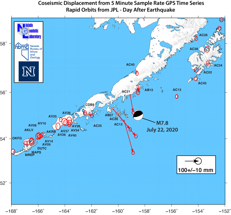
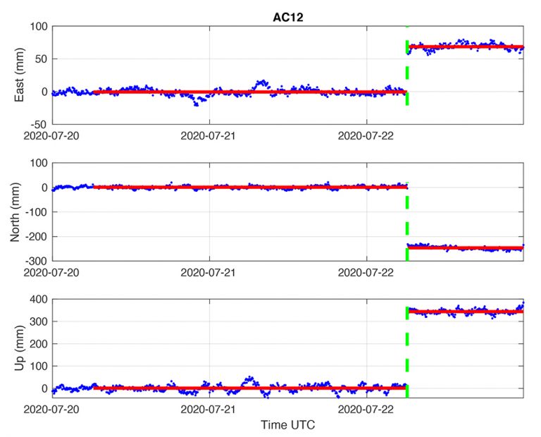
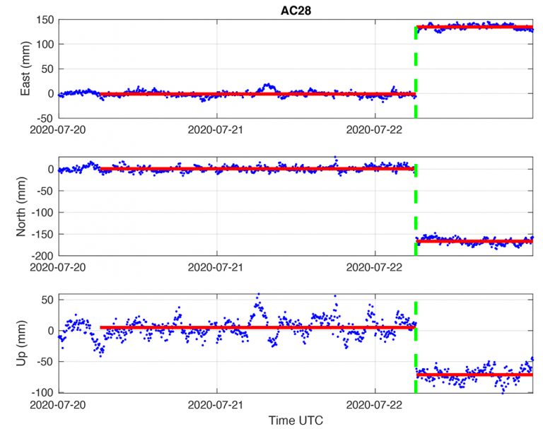
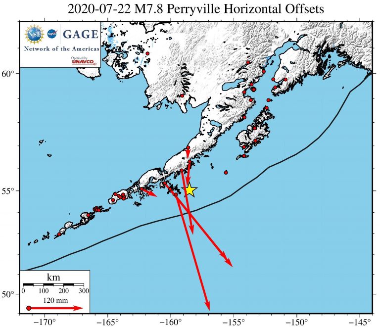
GAGE GPS/GNSS Displacement Estimates
The GAGE AC (MIT) inspects the NOTA GPS/GNSS daily positions for significant offsets when they have two to three days of post-event data. Offsets for this event are now available.
NOTA Borehole Strainmeter Data
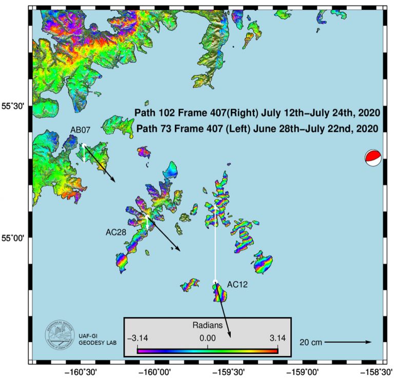
UNAVCO will produce a fully processed 1-sps borehole strainmeter (BSM) dataset for this event. This dataset can be downloaded from the UNAVCO borehole strainmeter event response page when it is ready. For an explaination of the strain plots (figures pending), see our Geophysical Event Response Data Explainer: Dynamic Strain.