
Terrestrial Laser Scanning (TLS) Project Support
GAGE provides Terrestrial Laser Scanning (TLS) support to Earth science researchers in the GAGE community. We maintain a pool of TLS scanners, as well as supporting field equipment (e.g., GPS systems, tripods), software, and staff trained in best practices for operation of these systems. The pool of TLS instruments provides a suite of capabilities in terms of instrument range (10cm to 2km), size and portability, scan speed, field of view, and multi-return and full waveform data capture. This diversity of instruments allows GAGE to support a wide range of Earth science applications.
Researchers and field course educators interested in utilizing GAGE TLS resources are encouraged to contact GAGE for additional information. We support TLS project planning, proposal preparation (including budgets and letters of support), instrumentation and field data collection, data processing, and online archiving of data. Request Support for TLS from GAGE if needed.
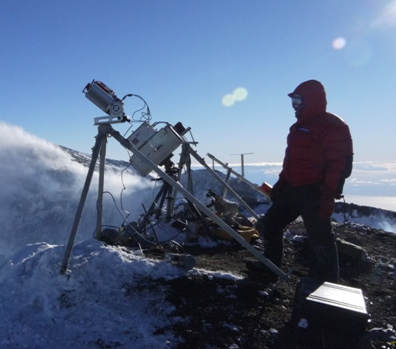
GAGE TLS system scanning the lava lake inside the summit crater of Mt. Erebus, Antarctica.
TLS, also known as ground-based lidar, is a versatile geodetic imaging technology in the Earth sciences. It offers unprecedented sub-centimeter-resolution of topographic and other surfaces, including 3-dimensional imagery of topography, rock or ice outcrops, caves, trees and vegetation, and cultural objects. TLS instruments are extremely precise, reasonably portable, relatively easy to operate, and have been used successfully in a variety of environments to support a wide range of geoscience investigations including detailed mapping of fault scarps, geologic outcrops, fault-surface roughness, frost polygons, volcanoes, lava lakes, dikes, fissures, glaciers, columnar joints, hillslopes, and drainage morphology. Moreover, repeat TLS surveys allow the imaging and measurement of surface changes through time, arising, for example, from fluvial erosion or landslides, volcanic deformation, ice flow, beach morphology transitions, and post-seismic fault slip. TLS is applicable to problems with length scales from the 10s of meters to kilometers. Concurrent GPS measurements are used to georeference the TLS data in absolute 3D coordinates. Coincident high-resolution digital photography allows for the generation of photorealistic 3D images.

Students at the Indiana University geologic field camp work with a GAGE TLS system.
The Earth sciences have embraced the application of TLS in many facets of research and education. GAGE provides a pool of TLS instrumentation and trained staff to make TLS technology more easily accessible to the Earth science community. GAGE is also a nexus for community activities such as workshops, short courses, and education and outreach efforts on multiple scales.
GAGE has also pioneered the use of TLS at geologic field camps. Over the past several years, GAGE has developed a growing program that involves bringing TLS systems to geology field camps throughout the West. In 2013, GAGE supported four geology camps and one graduate seminar class with TLS instrumentation, giving nearly 100 students the opportunity to design a TLS survey, operate the instruments, process data, and make geologic analyses using the high-resolution 3D datasets. The TLS and education program has been quite successful, growing annually, and nicely compliments more traditional methods taught during field courses.
Since 2008, GAGE has supported more than 150 TLS field projects, community training courses, and education and outreach activities.
The video below, created by USIP interns in 2016, provides an introduction to TLS project workflow.
Last modified: 2026-05-28 09:22:23 America/Denver