
This is one post in a series on the Alaska Amphibious Community Seismic Experiment blog following a field campaign in response to the magnitude 8.2 Chignik earthquake. (You can find the UNAVCO event response page for this earthquake here.) We are reprinting posts contributed by UNAVCO staff here but you can follow along on the blog to read the rest. This post comes from UNAVCO Project Manager Ken Austin.
From my own personal experience, I have been in 3 moderate to large earthquakes and have been involved in the response with all 3 in some form. The Mw 8.2 Chignik earthquake for me personally was the lightest felt due to distance (Anchorage) but within a few seconds of the light shaking starting I knew this was not a local aftershock and we were likely dealing with something very big.
UNAVCO, Inc. is a non-profit university consortium that supports research in all means of geodetic observations by providing equipment and engineering support, network management, data archiving and handling, education and outreach and training. The major operational component of UNAVCO is the National Science Foundation’s Geodetic Facility for the Advancement of Geoscience (GAGE). UNAVCO operates several programs under GAGE including support for Polar research, PI projects, and the Network of the Americas (NOTA), a 1150 station network of permanent GNSS stations that spans the lower 48 states, Alaska, the Caribbean and Mexico. Within Alaska UNAVCO is operating 118 GNSS stations as part of the NOTA network along with additional Investigator stations.
Immediately following the earthquake we assessed the station coverage and prioritized nearby offline stations for data recovery. Most of these stations were communications outages of various sorts and some were able to be recovered remotely working with providers and local contacts. Time is critical in this instance since the stations only have a 3-4 week buffer of high rate (1Hz).
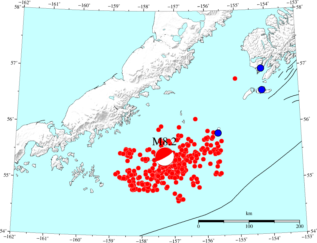
Three of these stations (AC02, AC45 and AC13) had dropped off 2 weeks prior to the earthquake. These three stations form a radio network that terminates in the Aleutiiq village of Akhiok on the SW corner of Kodiak Island. This network also supports 2 seismic stations (SII and CHI) operated by the Alaska Earthquake Center (AEC). Chirikof Island is a small uninhabited Island 80km or so west of Kodiak Island and very near the eastern rupture boundary of the Chignik Earthquake. This station along with one other to the north of the event were deemed the highest priority to recover the 1Hz and our standard 15s data, along with getting the seismic data back. These radio back through Sitkinak Island via radio repeaters at another AEC seismic station/Coastguard radio facility to a Satellite device in Akhiok. This dish had been receiving power from the village’s power plant to provide 24 hour communications for all 5 stations on the network. After speaking with the city manager, we discovered that they had installed a modernized power generation plant in a different location and built a new village power grid, and we would have to relocate the dish to this new location.
Everything to build or rebuild a station like this, and to support the engineers, has to be flown in to someplace like Akhiok. This village has a population of 50-60 people, there is no store or any way to source anything locally. The resulting cargo shipment from Anchorage to Kodiak was 400lbs including a new mast for mounting the dish and enclosure, and two backup batteries.
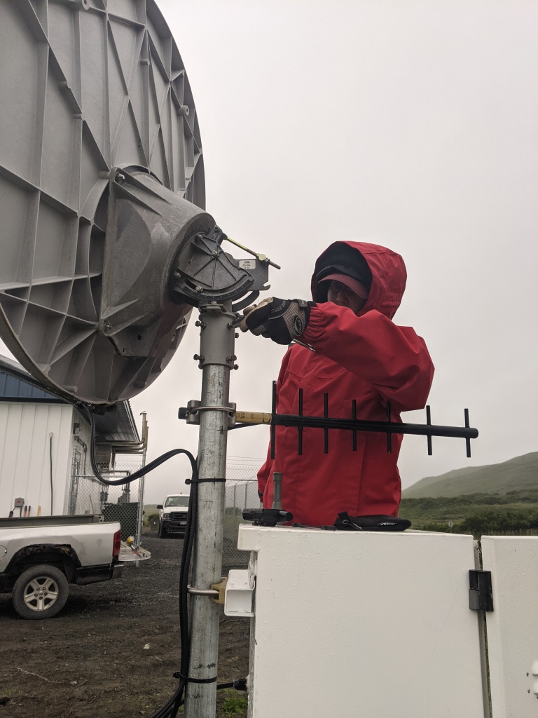
We arranged a place to stay in Akhiok and a vehicle to use as well as a chartered flight from Kodiak to transport us and the gear. All told, after purchasing concrete in Kodiak, we had 1100lbs of staff, equipment, and supplies. Sarah Doelger (NOTA East region manager) and myself flew out of Kodiak on August 10th to Akhiok. The first day was spent looking at a new location that had views of both the satellite dish path, the radio link to AC02 on the hill behind Akhiok, and a relatively short path to AC power for the equipment. The workflow plan was to set the new mast and lay the AC power to the power plant. Next step would be to dismantle the old site, move the dish and the enclosure to the new site while the concrete on the new post set. We assembled new dish mounting and support hardware, mounted the enclosure, and extra supports, then installed the dish. By the end of the day we were able to make an attempt to repoint the dish. After a few attempts and needing food and rest we let it be for the evening.
We woke up the morning of the 11th to heavy overcast skies and some rain. We started pointing the dish midmorning with no luck. These types of conditions can be the most difficult to point a satellite system with the excessive amounts of moisture in the air. The process is, in a gross sense, like finding a needle in a haystack. You start with a general direction and elevation for the satellite and manually move the dish, first coarsely to find the satellite, securing the dish then fine adjusting the peak. While performing this process we were actively downloading high rate data from the GNSS stations over the radio network with a separate computer. After a short break we found the satellite and were able to peak the signal as best as possible given the weather conditions. We completed the high rate downloads around the earthquake time and connected the network back to the satellite system, contacted another person at UNAVCO that they could see the system and the radio network and prepared to leave.
The thing about working in these remote villages, especially along the Pacific boundary is that weather can shut everything down. We had planned to return to Kodiak on a late afternoon charter on the 11th to allow time to sort gear to ship and get organized to return to Anchorage. The same weather and low visibility that hampered pointing the satellite system cancelled all flights that day and we spent an extra day in the village. This allowed us to spend time talking with the new teachers that had come in about educational opportunities, and just talk and get to know them and some of the other villagers. The better weather on the 12th allowed us to fine tune the dish pointing in the morning, further sort gear and finally depart the village with confirmation that the entire network was still online and transmitting data.
Written by:
- Ken Austin
- Posted: 14 August 2021
- Last updated: 14 August 2021
- Tags: Alaska, Chignik, project highlights
-

