)
Visualization
The GAGE Facility provides a variety of visualization tools that mostly support GPS/GNSS data sets at this time.
Interactive Maps
- The GPS Velocity Viewer allows exploration of NOTA-site geodetic plate velocities, or your own geodetic velocities, in various reference frames .
- Google Earth (kmz files)
- GPS/GNSS sites/monuments with data in the GAGE Archive including both permanent stations & campaign sites.
-
GNSS Permanent Stations (Right-click and Save As).
GAGE GNSS Data Availability - KML Network Link (Right-click and Copy Link Address and paste into Google Earth). - GNSS/GPS Campaign Sites (Right-click and Save As).
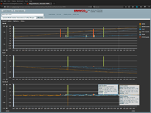
Time series plotting tools
- Interactive GNSS Position Timeseries Plotter dynamically plots North, East, and Vertical GPS/GNSS positions over time and optionally provides site maintenance event information.
- GNSS Position Timeseries Plotter Notebook (Embedded) (edit URL parameters to change station ID and dates).
Last modified: 2024-05-24 17:46:28 America/Denver