)
See our instructional video: How to Use the GPS Velocity Viewer.
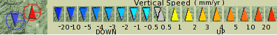
Key
GNSS data symbols

Other symbols
Learn More
- Learn more about GPS and GNSS velocity vectors: How quickly are we moving?
- Learn more about reference frames
- Reading Time Series Plots
Data Sources
GPS and GNSS
NSF GAGE Facility: GPS velocity data is available from GPS Data Products, which has these data sets:
- NAM14: https://gage-data.earthscope.org/archive/gnss/products/velocity/cwu.final_nam14.vel
- IGS14: https://gage-data.earthscope.org/archive/gnss/products/velocity/cwu.final_igs14.vel
The "filtered" versions of the two above data sources simply remove sites that have velocity sigmas larger than 2 mm/yr NE and 6 mm/yr vertical.
The GEM Strain Rate Map Project compiles velocity data from thousands of GPS/GNSS stations around the world, and models plate motions and crustal strain. The GSRM report is "A geodetic plate motion and Global Strain Rate Model," Kreemer, C., G. Blewitt, E.C. Klein, 2014, Geochemistry, Geophysics, Geosystems, 15, 3849-3889, doi:10.1002/2014GC005407.
Vertical speeds which are precisely zero are not plotted, as is the case for GEM data in 2015.
Earthquakes
Earthquake location data comes from the United States Geological Survey (USGS). You can search their catalog with the USGS Earthquake Search. There are three sets of earthquakes from this source: 4200 North American earthquakes with magnitudes of 4.5 or more, 6387 earthquakes in the western U.S. (lower 48 states) with magnitudes of 3.5 or more, and 10286 global earthquakes of magnitude 5.5 or more, all sets for the years 1995 through 2014. How many earthquakes are shown depends on the "How many markers displayed" choice. Color indicates depth of earthquakes (see the Key above). To find recent earthquakes, see Earthquakes from the USGS Earthquake Hazards Program.
Volcanoes
Smithsonian Global Volcanism Program.
All volcanoes are always shown, regardless of the "How many markers displayed" choice.
Tectonic Plates
From the USGS Google Earth™/KML Files pages Tectonic Plate Boundaries data file. Note that we are only using the plate boundaries from this data source. All plate boundaries are always shown, regardless of the "How many markers displayed" choice.
Help
If you have questions about the data values, please check with the data providers listed above. Ask us (send mail to: data-help![]() earthscope.org ) about this map tool and its displays.
earthscope.org ) about this map tool and its displays.
Last modified: 2026-03-09 18:06:37 America/Denver