
Course Overview | Using high resolution topography, UAVs, and GPS in undergraduate field education
Course Overview
- Dates: Tuesday August 15 - Friday 18, 2017
- Location: UNAVCO and nearby field sites, Boulder, Colorado (map of UNAVCO-Longmont area)
- Times: Course will begin at 6 pm on Tuesday August 15th, 2017 and end at noon on Friday August 18th.
- Please do not book flight departures before 2:30 pm on August 18 from Denver, CO.
Questions
Please contact Beth Pratt-Sitaula, UNAVCO prattsitaula![]() unavco.org
unavco.org
Applications
Applications are now closed (deadline was April 24, 2017)
Goals
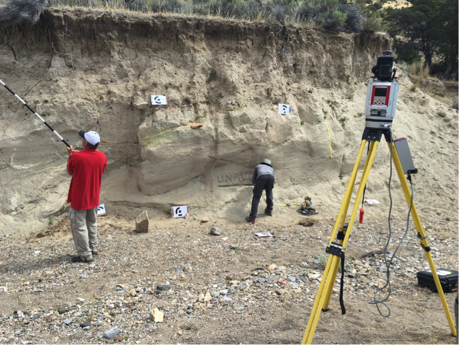
The goal of this workshop is to equip instructors of geoscience field courses with the knowledge and skills needed to integrate analysis of high-resolution topography into their courses. Using unmanned aerial vehicles (UAV) and ground-based platforms, participants will learn practical approaches for teaching structure from motion (SfM) photogrammetry and terrestrial laser scanning (TLS). Georeferencing will be done with kinematic GPS. The teaching resources that will be featured can be previewed at the GEodesy Tools for Societal Issues (GETSI) website. Featured geoscience applications include stratigraphic analysis for road cut engineering and parasequences, fault scarp analysis, and geomorphic change detection. We will also use this workshop as an opportunity to discuss best practices, learn about other uses of these technologies in field education, and to identify needs and recommendations for facility support of geodesy in field education.
Vision
Fieldwork is an integral part of the geosciences and there is a longstanding tradition of teaching field methods as part of the undergraduate curriculum. As geoscience research technologies have grown, there is more interest in introducing geodetic methods into field education courses. Technology integration into field education has several advantages, including student engagement and workforce development. This short course has been developed in response to community interest and input (e.g., Field Education and Support by the UNAVCO GAGE Facility workshop) and builds on successful pioneering efforts of UNAVCO community members.
Sponsors
![]() The primary sponsors of the short course are the GETSI Project, UNAVCO, and Septentrio. GETSI is an NSF-funded project to increase use of geodetic data and methods in undergraduate courses. The field education component of GETSI is collaborative between UNAVCO, Indiana University, and Idaho State University. UNAVCO, a non-profit university-governed consortium, runs NSF’s Geodetic Facility, which includes GPS support for researchers around the globe. Septentrio is a designer and manufacturer of high-end multi-frequency GPS/GNSS receivers and UNAVCO’s preferred vendor.
The primary sponsors of the short course are the GETSI Project, UNAVCO, and Septentrio. GETSI is an NSF-funded project to increase use of geodetic data and methods in undergraduate courses. The field education component of GETSI is collaborative between UNAVCO, Indiana University, and Idaho State University. UNAVCO, a non-profit university-governed consortium, runs NSF’s Geodetic Facility, which includes GPS support for researchers around the globe. Septentrio is a designer and manufacturer of high-end multi-frequency GPS/GNSS receivers and UNAVCO’s preferred vendor.
Travel and Costs
UNAVCO’s main office is located in Boulder, CO about 45-60 minutes from the Denver International Airport. The short course sponsors will provide food and shared housing during the short course, transportation to/from Denver International Airport and field sites, and a $400 stipend to offset travel costs for participants coming from outside the Denver/Boulder area. Stipend will be issued after full participation in the short course is complete.
Map of the UNAVCO & hotel in Longmont
Organizers & Presenters
- Beth Pratt-Sitaula, UNAVCO, prattsitaula
 unavco.org
 - Yonathan Admassu, James Madison University
- Michael Bunds, Utah Valley University
- Chris Crosby, UNAVCO
Last modified: 2020-04-16 03:14:36 America/Denver