
The Global Navigation Satellite System (GNSS) has become an instrumental part of our daily lives. It is used for things like navigation, land surveying, and mapping, just to name a few. While the geodetic applications of GNSS are incredibly powerful, they do encounter limitations because of unknowns in their calculations. One important factor that contributes to these errors is tropospheric delay, which adds uncertainty to the location calculations because of variable delay in the signal traveling from the satellite to the receiver.
Part of the tropospheric delay is caused by the gases that are present in the troposphere (nitrogen, oxygen, argon, etc.) and can vary with temperature and atmospheric pressure—this is called the hydrostatic delay. The other component of the delay is due to water vapor and the condensed water that is found in clouds, making it very dependent on weather conditions.
In a recent issue of GPS Solutions, a study led by Hang Su of the University of Chinese Academy of Sciences, explored the effect of atmospheric pressure and hydrostatic delay on geodetic applications supported by GNSS. Since the accuracy of the calculated hydrostatic delay relies heavily on the variations of atmospheric pressure, this variable is a key measurement for precisely determining the overall tropospheric delay. To do this, the research team examined 17 years of data for the locations of 320 GNSS stations with a goal of refining the delay caused by hydrostatic delay. In doing so, the measurements recorded by GNSS instruments can be more precise.
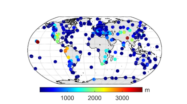
Using data from the European Center for Medium-range Weather Forecasts Reanalysis (ERA5), a dataset with hourly estimates of weather variables, Hang Su’s team calculated the atmospheric pressure at the heights of the 320 GNSS stations as seen in the figure above. While atmospheric pressure can be directly measured by certain instruments, it is difficult to obtain accurate results on a global scale from an individual instrument. To mitigate this, a standard pressure calculation method was developed in 1948 and is commonly used today.
This standard method, however, can present greater error in atmospheric pressure and hydrostatic delay calculations if the GNSS station is at a higher elevation. The research team sought to optimize this standard method by incorporating latitude and temperature, in addition to height, into the equation. Since the standard method only accounts for height, this does make the process more complicated, but with this optimization, they proposed a revised atmospheric pressure model based on 17 years of GNSS data.
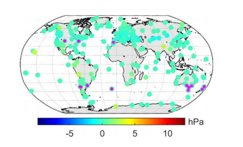
These modified models could provide a more accurate method to determine local and global atmospheric pressures, thus reducing hydrostatic delay errors. When they tested their improved models, they reported a roughly 50% improvement in their calculated pressures. An increase in location accuracy can be especially useful in geodesy, where we use GPS stations around the world to understand how Earth’s crust is moving and deforming over time, as well as earthquake hazards. Work that shrinks uncertainties has also opened new doors. Now, stations are also used to measure atmospheric water vapor based on tropospheric delay. An improved calculation for the components of that delay could aid those measurements, as well.
Written by:
- Courtenay Duzet, USIP Intern
- Posted: 29 July 2021
- Last updated: 26 July 2021
- Tags: GPS/GNSS
-

