

Why have a GPS station in the middle of a lake? Based on a recent study published by Lucas Holden at RMIT University and Kristine Larson and the University of Colorado Boulder in the Journal of Geodesy, the reflection of the satellite signal can actually allow the station to precisely measure the changing water level around it. The researchers tested this out with ten years of data at Lake Taupō, New Zealand.
Stations that use more than just the American GPS satellite network are referred to as GNSS (Global Navigation Satellite System) stations. Going a step further, the technique in use here is called “GNSS Interferometric Reflectometry” (or GNSS-IR). It’s based on the interference pattern produced from the direct signal, used for positioning, and the reflected signal bouncing off the surface below the antenna. This interference pattern can be measured by the signal-to-noise ratio—the closer the antenna is to the surface, the stronger the noise.
GNSS-IR can be applied to determine water surface levels. With known values for certain factors in the signal-to-noise ratio, like the surface roughness and satellite elevation angle, the distance between the surface and the antenna can be calculated. The distance between the antenna and the surface (in this case the water) increases as the water level decreases, so the researchers calculated the lake level daily using this technique.
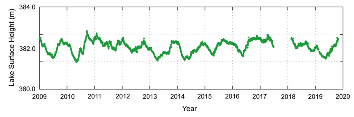
The station that researchers examined was approximately 4 kilometers from Lake Taupō’s shoreline and fixed on a platform attached to the lake bottom. This station is part of New Zealand’s GNSS network to monitor crustal deformation. Measurements over the past few decades have shown long-term subsidence of the lakebed in the northern portion in addition to shorter-term, localized uplift and subsidence of other portions. This active deformation is due to regional tectonic, hydrothermal, and magmatic processes.
The surface height of the lake is regularly measured by gauges at Acacia Bay and Tokaanu. The researchers found that their calculated lake heights were an excellent match with the shoreline gauges.
The calculated lake heights were also compared to satellite altimetry measurements from the G-REALM and DAHITI satellite databases. The difference between the two was about 0.2-0.4 meters, depending on the database. Previous studies comparing water levels detected by satellite altimetry and gauges found differences ranging from tens of centimeters to meters, so the discrepancies observed between the GNSS-IR and satellite altimetry could be due to sources of error in the satellite altimetry measurements.
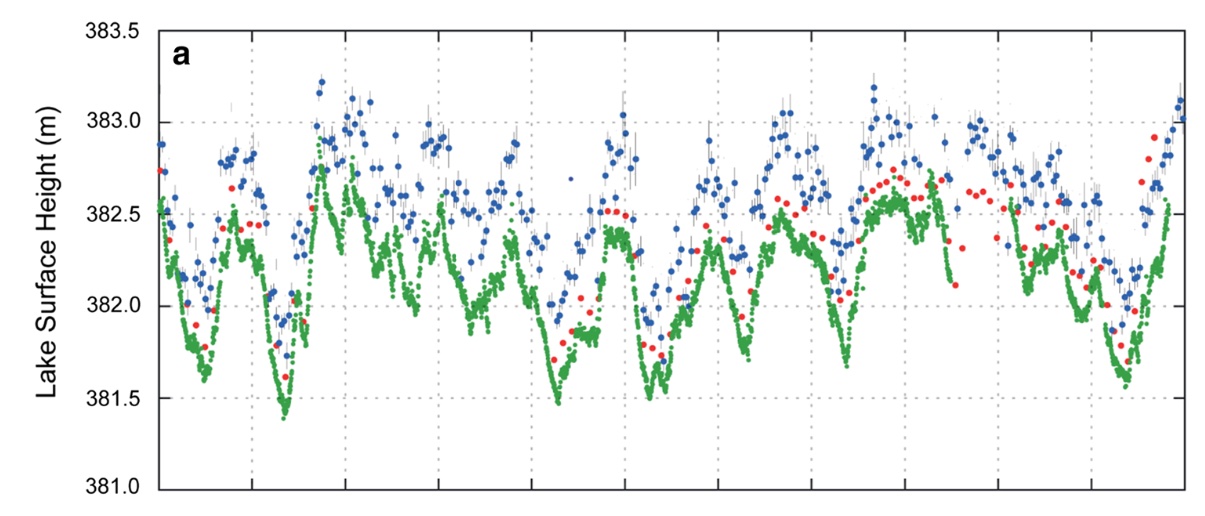
Satellite radar altimetry measures the average height within a set area (the radar footprint), not the height at a specific point. The impacts of lake contours, local wind, and differing locations of the radar footprints could all contribute to the difference in the water level observed by satellite altimetry as opposed to GNSS-IR. Because Lake Taupō is relatively small, the application of satellite altimetry for water level measurements is particularly difficult. After applying a five-day average to the dataset, the difference between the tidal gauge and GNSS-IR observations range from 0.019-0.020 meters.
So why have a GNSS station in the middle of a lake? Because it can measure changing lake levels! This could also potentially become a cost-effective method to calibrate satellite altimetry data. Since the station is attached to the lakebed, it can account for ground deformation separately from the water level—and serve as a calibration point for both.
Written by:
- Lucia Bellino, USIP Intern
- Posted: 27 July 2021
- Last updated: 23 July 2021
- Tags: GPS/GNSS
-

