
Tropospheric Data
The GAGE Analysis Centers (ACs) process raw GPS data and produce position solutions for PBO and other stations. As part of GAGE processing of daily data, the ACs estimate tropospheric parameters. Radio signals from GPS satellites are refracted and slowed down (i.e. delayed) when they pass through the Earth's atmosphere, and the resulting tropospheric delay must be accounted for. ACs solve for and release the total zenith delay and its components, the wet zenith delay and hydrostatic zenith delay.
Surface Met Data
Search Surface Met Data
Surface Met Data is available from GPS/GNSS sites with meteorological sensors (current Met sites), held in the GPS/GNSS archive of the GAGE Data Center. The met sensors measure air temperature, relative humidity and atmospheric pressure and possibly other parameters such as wind speed and direction and rainfall.
Tropospheric Processing Products
Get Tropospheric Processing Products
Tropospheric Processing Products are generated by GAGE post-processing of daily GPS data using the Niell Mapping Function.
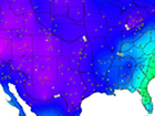
Integrated Precipitable Water Vapor (PWV)
Get Integrated PWV
Integrated Precipitable Water Vapor (PWV) are calculated from zenith wet delays estimated across the conterminous US and the Caribbean by the UCAR COSMIC/SuomiNet program which uses GPS Data from the NOTA Network operated by the GAGE Facility (formerly the PBO and COCONet networks), Suominet + NOAA, USCG/USACE, DOT, and other sites. The zenith wet delay depends upon tropospheric water in vapor form and condensed as clouds, and it varies rapidly over time and distance.
Last modified: 2023-09-12 11:24:38 America/Denver