
Trinidad and Tobago Neotectonics and Seismic Hazard from Geodesy
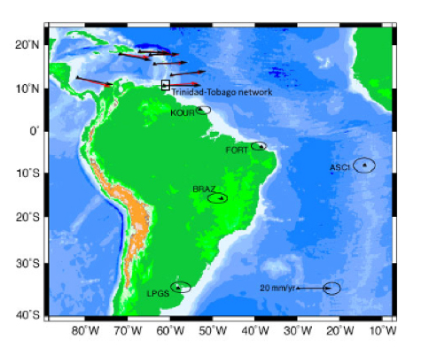
Map showing the first GPS-derived motion (black vectors – observed motions) of the Caribbean (CA) plate (red vectors – rigid CA plate model) in a fixed South American plate reference frame, and location of the Trinidad-Tobago GPS network. Modified from Weber et al. (2001). (Image provided by John Weber, Grand Valley State University) 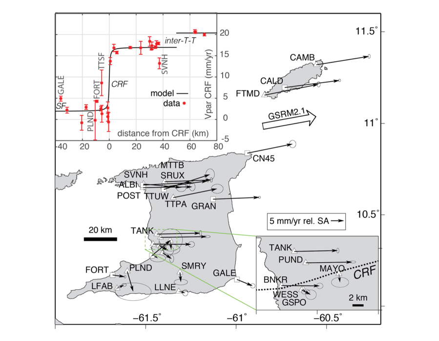
Trinidad-Tobago GPS-derived horizontal velocity field (Weber et al., 2019) in a fixed South American plate reference frame (Kreemer et al., 2014). Triangles show episodic GPS sites; squares show continuous GPS sites. Inset: site velocity near Central Range Fault. Modified from Weber et al., 2019. (Image provided by John Weber, Grand Valley State University) 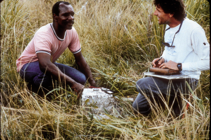
Murchison Pierre (Trinidad-Tobago government surveyor) and John Weber examine a Tobago historic (1920s) survey pillar during 1990s reconnaissance and GPS occupation of Trinidad-Tobago’s historic triangulation networks. (Image provided by John Weber, Grand Valley State University) 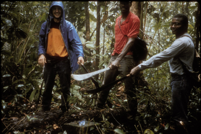
John Weber, William Ambeh, and Stephen Williams (local guide) recovering one of Trinidad’s historic (1901-03) mountaintop survey pillars during 1990s reconnaissance and GPS occupation of Trinidad-Tobago’s historic triangulation networks. (Image provided by John Weber, Grand Valley State University)
Overview
The rich and varied landscapes and geology of Trinidad and Tobago, a twin-island nation in the southeast Caribbean, reflect a complex, multi-phase tectonic history. Trinidad-Tobago makes up the eastern part of the southern Caribbean orogen, a range of coastal collisional mountains that rim northern South America and were initially thought to be an eastern arm of the Andes. Today, these two islands experience ~20 mm/yr of Caribbean-South American (CA-SA) dextral transform plate-boundary motion and deformation, as well as additional motions and strain related to surface-to-deep coupling above a lithospheric-scale subduction-transform edge propagation (STEP) system.
We characterized the velocities and strain rates in Trinidad-Tobago using historic triangulation-to-GPS, episodic GPS, continuous GPS, and InSAR data. Approximately 75% of the transform motion (15 mm/yr) is taken up on Trinidad’s Central Range Fault via fault creep. The remaining transform motion occurs on Trinidad’s South Coast Fault (3 mm/yr of creep), and on the Sub-Tobago Terrane Fault (3 mm/yr), a reactivated low-angle thrust.
Creep on the central and south Trinidad faults is likely related to a strong petroleum charge (i.e., fluid overpressures) that results from active expulsion of oil and gas from buried organic-rich Cretaceous petroleum source rocks. In contrast, Tobago is made up of a Cretaceous arc and forearc that were accreted to South America during Tertiary oblique plate convergence. Both new and reactivated Tertiary faults accommodate strain in Tobago and have created moderate to large earthquakes.
Our geodetic analyses have been complemented by additional studies that use paleoseismology, thermochronology, terrestrial cosmogenic nuclides, and optically stimulated luminescence to study longer-term horizontal and vertical motions, and to assess predictions made by the STEP model. We are also currently expanding GPS and InSAR coverage to study fault coupling and creep along a broader swath of the Caribbean-South American plate boundary.
UNAVCO has supported our episodic GPS measurement campaigns and in our most recent analysis we used continuous GPS data from the Network of the Americas (NOTA, formerly COCONet), which is maintained by UNAVCO as a core component of the National Science Foundation GAGE Facility.
Project Information
Principle Investigator(s): John Weber, Grand Valley State University (GVSU); William Ambeh, Joan L. Latchman, Richard Robertson, Seismic Research Centre, The University of the West Indies; Peter La Femina and Machel Higgins, The Pennsylvania State University; Halldor Geirsson, University of Iceland; Jarir Saleh*, Keith Miller, Geomatics Engineering and Land Management, The University of the West Indies (*now at the U.S. National Geodetic Survey)
UNAVCO staff: Brennan O’Neill; Jim Normadeau
Location: Trinidad and Tobago (map)
Funding Source(s): California Institute of Technology President’s Fund, BHP-Billiton, NASA Michigan Space Grant Consortium, GVSU, Trinidad and Tobago Office of Disaster Management and Preparation, NSF COCONet Fellowship
References
Arkle, J., Owen, L., Weber, J., Caffee, M., and Hammer, S., 2017, Transient Quaternary erosion and tectonic inversion of the Northern Range, Trinidad, Geomorphology, 295, 337-353, http://dx.doi.org/10.1016/
j.geomorph.2017.07.013.
Prentice, C., Weber, J., Crosby, C., and Ragona, D., 2010, Prehistoric earthquakes on the Caribbean-South American plate boundary, Central Range Fault, Trinidad, Geology, 38, 8, 657-678, doi:10.1130/G30927.1.
Weber, J.C., Dixon, T.H., DeMets, C., Ambeh, W. B., Jansma, P., Mattioli, G., Saleh, J., Sella, G., Bilham, R., and Perez, O., 2001, GPS Estimate of relative motion between the Caribbean and South American plates, and geologic implications for Trinidad and Venezuela, Geology, 29, 75-78.
Weber, J., Saleh, J., Balkaransingh, S., Dixon, T., Ambeh, W., Leong, T., Rodriguez, A., and Miller, K., 2011, Triangulation-to-GPS and GPS-to-GPS geodesy in Trinidad, West Indies: Neotectonics, seismic risk, and geologic implications, Journal Petroleum and Marine Geology, v.28, p.200-211, doi:10.1016/j.marpetgeo.2009.07.010.
Weber, J., Geirsson, H., Latchman, J., Shaw, K., La Femina, P., Wdowinski, S., Churches, C., Higgins, M., and Norabuena, E., 2015, Tectonic inversion in the Caribbean-South American plate boundary: GPS Geodesy, Seismology, and Tectonics of the Mw 6.7 April 22, 1997 Tobago earthquake, Tectonics, 34, 6, 1181-1194, DOI: 10.1002/2014TC00366.
Weber, J., Geirsson, H., La Femina, P., Robertson, R., Churches, C., Shaw, K., Latchman, J., Higgins, M., and Miller, K., 2019, Fault creep and strain partitioning in Trinidad‐Tobago: Geodetic measurements, models, and origin of creep. Tectonics, 38. https:// doi.org/10.1029/2019TC005530.
This Community Highlight features the work of UNAVCO community members’ efforts to increase access to, use of, and innovation within geodesy. If there is an effort you would like to see highlighted here, please get in touch with us at community![]() unavco.org.
unavco.org.
Written by:
- John Weber, Grand Valley State University
- Posted: 30 December 2019
- Last updated: 4 June 2021
- Tags: GPS/GNSS, project highlights
-

