
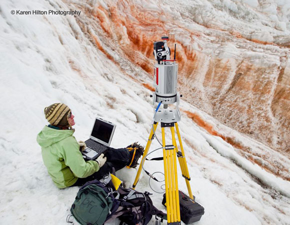
Marianne Okal performs a LiDAR scan at Blood Falls in the Taylor Valley. photo by Karen Hilton. 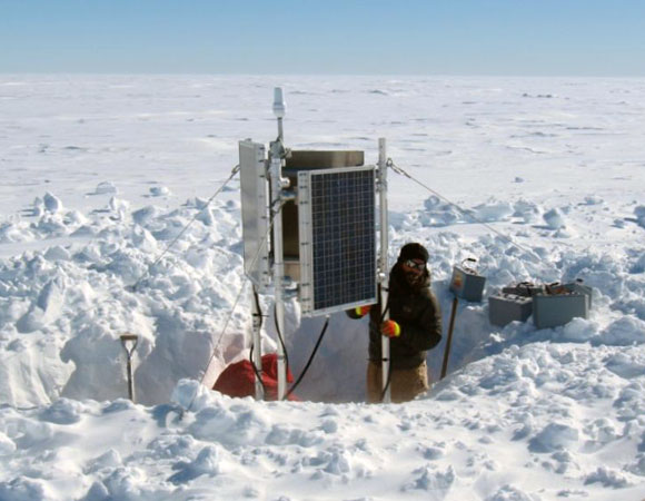
Jeremy Miner raising GPS station above snow accumulation for ANDRILL study. Photo by Seth White. 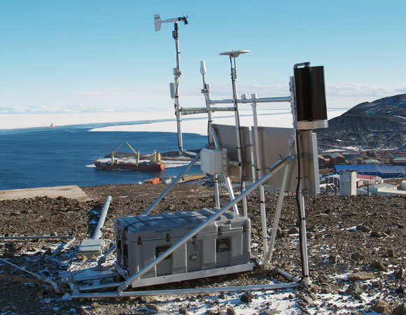
UNAVCO test station on Observation Hill near McMurdo, testing weather station and turbine for 2012. Photo by Seth White.
Project Overview
UNAVCO provides geodetic support to NSF-OPP funded scientific investigators working in the Arctic and Antarctic. Survey grade GPS receivers, terrestrial laser scanners, and supporting power and communications systems for continuous data collection and campaign surveying are available. Operation and maintenance services are also provided for long term data collection, with on-line data distribution from the UNAVCO community archive. Request Support if needed.
During the 2011-12 Antarctic field season, UNAVCO deployed 5 engineers, 88 GPS receivers, 3 Terrestrial Laser Scanner (TLS) instruments, and a large volume of ancillary equipment in support of a record 34 PI science projects. Including 2 more field engineer and 14 receiver deployments as part of the POLENET project, along with 93 receivers already installed at existing continuous GPS stations throughout Antarctica, a total of 7 UNAVCO personnel (a record), 195 GPS receivers, and 3 TLS instruments were present in Antarctica during this field season.
During the season UNAVCO maintained a continuous presence at McMurdo station, providing equipment, training, data processing, and logistical support to science groups. Field engineers also assisted with field work for numerous projects, in the vicinity of McMurdo Station and throughout West Antarctica.
Highlights from the Field Season
- Five remote GPS stations were delivered to Pine Island Glacier camp for installation on the glacier. Training was provided at McMurdo to the PI field team (Bindschadler / Truffer). Due to logistics constraints only two days aircraft time were available for installation, however the PI group successfully built all five stations in this time. One of these stations is equipped with a Xeos XI-100 modem for data telemetry to UNAVCO.
- Seven PI projects received LiDAR support. On Mt. Erebus, repeat scans were performed of the lava lake and inner crater, and two major ice cave networks were imaged for the science group (Kyle). Studies of glacial landscapes also continued at for several PI’s at various locations in the Dry Valleys, including Miers, Taylor, Garwood, and Beacon valleys.
- Two remote, autonomous power systems were constructed in support of non-geodetic instrumentation. A ~10W power system was delivered to support an oceanographic temperature profiler instrument, installed on the Ross Ice Shelf at Windless Bight (Holland / Tyler). A second ~3W power system was built for ground-level ozone instrument, installed at Marble Point (Avallone / Kalnajs).
- A prototype weather station was installed at the UNAVCO GPS test station on Observation Hill near McMurdo. This weather station, developed in conjunction with the University of Wisconsin Automatic Weather Station project (Lazarra) features integrated power and communications with the GPS equipment. This is a proof-of-concept to demonstrate how existing GPS stations can be retrofitted with Antarctic-grade weather instruments.
- A new GPS monument was installed at the Lake Fryxell camp, with antenna and cabling to streamline future surveying tasks in the area.
- Numerous campaign GPS systems were provided deployed across all of West Antarctica from Victoria Land to the Antarctic Peninsula.
- Upgrade kits were provided to the LARISSA project for two stations. Maintenance at one site was performed by the PI group (Domack / Scambos) and the other was performed by technical staff from the Laurence M. Gould during a research cruise.
- Two GPS electronics boards were provided to University of Newcastle (King) on a full cost recovery basis. These systems were installed on the Antarctic Peninsula by the 2012 British Services Antarctic Expedition.
- Community base stations at McMurdo and South Pole were upgraded to Trimble NetR8 receivers, replacing older NetRS models. Also, the RTK system at the McMurdo base station was re-located from Crater Hill to Building 71. This will eliminate operational hassles due to aging telecom infrastructure and human interference.
- UNAVCO continues to gain experience with new Trimble NetR9 receivers and Xeos Iridium modems. In addition, we now support the new Trimble Business Center GPS data processing software, replacing older, obsolete processing software.
- The volume of equipment that UNAVCO now handles each season has outgrown the space available in the Crary Lab at McMurdo. We are exploring possibilities for improved, dedicated office and staging space at McMurdo with Lockheed, the USAP logistics contractor.
Project Information
- Principal Investigators: Various
- UNAVCO Engineers: Joe Pettit, Marianne Okal, Seth White, Mike Gottlieb, Bjorn Johns
- Dates: October 2011- February 2012
- Location: Antarctica
Related Links
Written by:
- Seth White
- Posted: 19 July 2012
- Last updated: 19 July 2021
- Tags: Antarctica, GPS/GNSS, project highlights, TLS
-

