
Fieldwork has long been considered an essential part of the geosciences. EarthScope supports the inclusion of geodetic field methods and data analysis into undergraduate and graduate courses with field components. Resources available allow field education programs to update technical knowledge on integrating geodetic methods such as terrestrial laser scanning (TLS), structure from motion (SfM) photogrammetry, and static and kinematic GPS into courses.
Topics
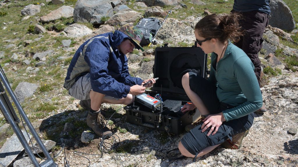
Field education is an excellent opportunity to increase knowledge of geodesy and geodetic technologies for future members of the geoscience workforce. EarthScope has experience integrating terrestrial laser scanning (TLS), structure from motion (SfM), and GPS into undergraduate and graduate field courses. EarthScope staff can work with instructors to implement teaching resources, estimate financial support needed for EarthScope-supplied TLS, SfM, and GPS equipment and trained staff to assist with using these tools in a teaching environment.
Teaching kits of ~5 Emlid Reach RS2 GPS/GNSS receivers (1 base, 4 rovers) can be borrowed to support student learning of RTK GPS. The loan is free but shipping costs may apply. See more information on the GETSI GPS/GNSS Field Equipment page. We recommend contacting education![]() unavco.org if you are thinking about using geodesy methods in your teaching.
unavco.org if you are thinking about using geodesy methods in your teaching.
If you are interested in receiving support for Field Education, please complete both forms below. Before completing the Field Education Supplemental Support Request form, please review the questions as some consideration is necessary to complete the request. Additional guidance can be found on the Equipment page.
As part of the GEodesy Tools for Societal Issues (GETSI) project, EarthScope, and community partners have developed curricular resources to aid in teaching field geodetic methods. Resources are appropriate for undergraduate and some graduate field courses.
Two modules from GETSI can be found below:
Analyzing High Resolution Topography with TLS and SfM
High Precision Positioning with Static and Kinematic GPS/GNSS
Learning manuals for field geodetic techniques have been developed to support teaching of these methods to undergraduates. These manuals can also be useful for investigators and graduate students interested to learn more about these methods for research.
Downloadable manuals are included below:
These reports led to the development of Field Education Support at UNAVCO.
- 2015 Final Workshop Report: The Role of UNAVCO in Geodesy and Field Education (PDF)
- 2012 Final Project Report: Community Workshop: Charting the Future of Terrestrial Laser Scanning (TLS) in the Earth Sciences and Related Fields, NSF Award 1138279 (PDF)
- 2009: Collaborative Research MRI: Acquisition of Terrestrial Laser Scanning Systems for Earth Science Research, NSF Award 0923548 (PDF)
Charlevoix, D., (2014), Workshop to Assess Field Education Support by the GAGE Facility. Accessed 24 August 2016, http://www.unavco.org/highlights/2015/fieldedworkshop.html.
Douglas, B., N. Niemi, G. Wang, D. Charlevoix, C. Crosby, B, Pratt-Sitaula, (2015), Final Workshop Report (pdf): The Role of UNAVCO in Geodesy and Field Education, UNAVCO. Accessed 24 August 2016, http://www.unavco.org/education/professional-development/short-courses/2014/field-education/field-education.html.
Direct Link: http://www.unavco.org/education/professional-development/short-courses/2014/field-education/14-field-educ-report-final.pdf.
Miller, M. M., C. Meertens, D. A. Phillips, C. Rubin, L. Ely, B. Pratt-Sitaula, (2009), Collaborative Research MRI: Acquisition of Terrestrial Laser Scanning Systems for Earth Science Research, Final Project Report, NSF Award 0923548. Accessed 24 August 2016, http://www.unavco.org/community/publications_and_reports/proposals/proposals.html.
Direct Link: http://www.unavco.org/community/publications_and_reports/proposals/2009/MRI_TLS_EAR2009_UNAVCO-CWU.pdf
Phillips, D. A., J. S. Oldow and J. D. Walker, (2012a), Outlining a strategic vision for terrestrial geodetic imaging, Eos Trans. AGU, 93(11), 121. Accessed 24 August 2016, http://onlinelibrary.wiley.com/doi/10.1029/2012EO110005/full.
Direct Link: http://onlinelibrary.wiley.com/doi/10.1029/2012EO110005/epdf
Phillips, D. A., J. S. Oldow, J. D. Walker, J. R. Arrowsmith and C. M. Meertens, (2012b), Community Workshop: Charting the Future of Terrestrial Laser Scanning (TLS) in the Earth Sciences and Related Fields, Final Project Report, NSF Award 1138279. Accessed 24 August 2016, http://www.unavco.org/community/meetings-events/2011/tls/tls.html.
Direct Link: http://www.unavco.org/community/publications_and_reports/reports/past-grants/final-reports/TLS_Workshop_NSF_Final_Report_1138279.pdf.
Pratt-Sitaula, B., B. Crosby, C. Crosby, (2017), Integrating Topographic Imaging into Geoscience Field Courses: Using TLS and Structure from Motion (SfM) Photogrammetry in Undergraduate Field Education; Cardwell, Montana, 16–19 August 2016, Eos, 98, https://doi.org/10.1029/2017EO067411. Published on 07 February 2017.
Home
- Education
- Education Resources
- Last updated: 16 May 2023