The format is shown in examples below. The files have one observation per line, with comma separated values, hence the files are called csv files. The files have a special two-line header that tells the IDV what is in the file, the variables' names and units, and how they are related. You can have several variables on each line.
Complete details about these csv files are in the Unidata IDV User's Guide: Text (ASCII) Point Data Format.
Each observation must have a time, and latitude and longitude, and usually has an Altitude (depth) for geophysics data. The lines must have one data value of some kind per location (line). A file of only a location( latitude, longitude, and altitude (depth) values) will not be accepted by the IDV, but you can provide a text label for a location and that will work.
The files must end with the file extension ".csv" -- that is how the IDV knows the file format and how to read it.
One or more time can apply to each location; each time is of course a different observation (line in the file). Or you can supply the same time to several observations. The IDV can show time animation, or all values at once, in one display. The IDV can show progressive accumulation by time of points values, typically showing earthquake aftershocks appearing after a main earthquake.
The nature of geophysical data often requires multiple parameters per observation, for example, GPS velocity vectors and earthquake focal mechanisms are described by more than one value. The IDV knows which value is which in these certain cases by using reserved or special variable names; see the examples listed below. If you do not use the right name for a variable, the IDV will not know what it means and cannot use it in special plots.
The variable names appear in the top two header lines only. Do not alter the header, except to change the field names and unit names as needed.
If your data type is not one of the geophysics examples, you can use your own, new, different, parameter names in the file and the IDV will be able to plot it with a variety of symbols. The geophysical examples are for data cases which have special symbols in geophysics and in the IDV.
Depth is called "Altitude," and is negative downwards below the "surface" (value 0) in these csv files. Longitude west is negative.
GPS vectors and error ellipses variables Time,Latitude,Longitude,Altitude,vn,ve,vz,stddevN,stddevE,stddevU,corrNE,corrNU,corrEU,IDN
seismicity variables Time,Latitude,Longitude,Altitude,magnitude
earthquake focal mechanisms varibles Time,Latitude,Longitude,Altitude,magnitude,strike,dip,rake. Also, "slip" may be used in place of "rake." The comment and Mo are optional and not used in beachabll plots.
seismic anisotropy variable names Time,Latitude,Longitude,Altitude,phi,dt,azimuth_error,delta_t_error
generic example with four fields
plottable surface station locations with 4 character ids (times need not be sequential). Use Layout model 'Labeled Locations," and see the section "Loading into the IDV."
Loading Point Data into the IDV
Finally, after you have created your file, make your IDV display.
If needed, create a Layout (station) model for those variables using the IDV's menu "Tools->Layout Model Editor." Usually you do not need to do this. The IDV comes ready to plot generic symbols for most data.
Then, when you run the IDV to read your data:
Enter the data's location in the Dashboard's Data Chooser entry box for Files or URLs.
Use Data Source Type as "Text Point Data files"
Seelct Field 'Point Data.' Use the "Point Data Plot" for the Display. Click Create display.
Use the display control to set decluttering, size, etc., and if needed, select an appropriate Layout model
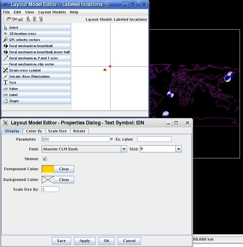
For labeling stations, the csv data file variable name 'IDN' i (as in this file) is specially recognized by the IDV layout model 'Labeled Locations.' You can make your own station 'layout model' with the layout model editor, setting choice of variable name, text color and size, etc. Choose Tools->Layount Model editor; select a layout model, and do a right button click on the symbol in the right area to change prpoerties:
Creating an IDV point data file with the IDV
If you have a comma separated value ASCII file, and do not wish to use a editor to compose the special header lines, you can use the IDV to create the special two header lines. See the section "Using the Text Point Metadata Gui" in the User's Guide: Text (ASCII) Point Data Format.
Saving a point data csv file with the IDV
If you have point data in another format that the IDV displays, such as NetCDF, you can make a csv file shows the list, click on "Select Fields." Add all the fields in the All Fields column to the Current Fields column with the Add button, and click on OK. Click on the "Show raw data" checkbox (or the IDV will round your data values to nearest tenths). Then do File->Save->Export Table, and enter a filename ending with .csv.